
Suburban Development Area Core Neighbourhoods Settled 1884 Area 172 ha Population 2,232 (2009) | Neighbourhood Westmount Incorporated (as Saskatoon) 1906 Local time Saturday 6:27 AM | |
 | ||
Weather 2°C, Wind S at 23 km/h, 84% Humidity | ||
Westmount is an older inner city neighbourhood located near the centre of Saskatoon, Saskatchewan, Canada. It mostly consists of low-density, single detached dwellings. As of 2009, the area is home to 2,232 residents. The neighbourhood is considered a lower-income area, with an average family income of $44,729, an average dwelling value of $162,491 and a home ownership rate of 68.9%. According to MLS data, the average sale price of a home as of 2013 was $207,347.
Contents
- Map of Westmount Saskatoon SK Canada
- History
- Government and politics
- Education
- Other
- Parks and recreation
- Commercial
- Location
- References
Map of Westmount, Saskatoon, SK, Canada
History
The area that now makes up Westmount was settled by homesteaders in 1884, as the east bank settlement of Saskatoon struggled for survival. A settler named Archibald L. Brown was one such landowner, owning a section of land where Westmount School would later be built. The neighbourhood was within the city limits when the City of Saskatoon incorporated in 1906. At that time it was the city's northwest corner, hence the name. The streets in Westmount are named for early settlers of the Saskatoon area, and most of the houses were built prior to 1960.
The neighbourhood appeared on a surveyors' map in 1911. The current boundaries of Westmount include some of an area called Ruskin Place, which appears on a 1913 map of registered subdivisions.
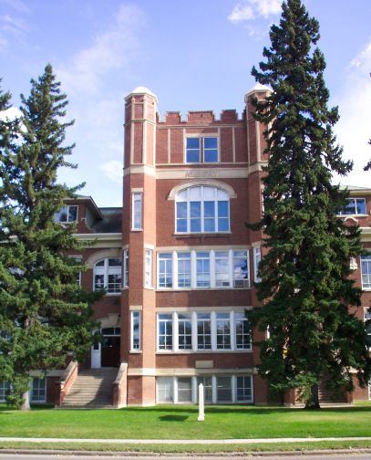
Westmount School was opened on April 3, 1913. It was designed by architect David Webster, who designed six of Saskatoon's Collegiate Gothic style elementary schools between 1910 and 1914. E.D. Feehan High School was opened in 1967, and named in honour of Edward Daniel Feehan, a former superintendent of separate schools in Saskatoon. It is designated a bilingual English and Ukrainian school, and also has classes in Cree and Spanish.
McMillan Avenue, which forms part of Westmount's western boundary, is named for Frank MacMillan. He was a Toronto businessman who moved to Saskatoon, owned several successful businesses, and built several landmark buildings downtown. He would serve as Saskatoon's mayor and later a Member of Parliament.
Development prior to 1927 was haphazard, which sometimes resulted in irregularity between neighbourhood streets between Westmount and Caswell Hill. In 1927, the first formal town planning board was established. Westmount was zoned Residence A District, which limited development to one and two-family houses of no more than two-and-a-half storeys.
In its recent history, Westmount has become a lower-income inner city neighbourhood. It and other core neighbourhoods have been the recipients of affordable housing and community economic development initiatives to improve the lives of residents.
Government and politics
Westmount exists within the federal electoral district of Saskatoon West. It is currently represented by Sheri Benson of the New DemocraticParty of Canada, elected in 2015.
Provincially, the area overlaps two constituencies. The south part lies within the constituency of Saskatoon Centre. It is currently represented by David Forbes of the Saskatchewan New Democratic Party (NDP), first elected in 2001 in a 2001 by-election and re-elected 2003, 2007 and 2011. The south part lies within the constituency of Saskatoon Massey Place. It is currently represented by Cam Broten of the NDP, elected in 2007.
In Saskatoon's non-partisan municipal politics, Westmount lies within ward 4. It is currently represented by Councillor Troy Davies. He was first elected to city council in 2012 taking the seat that was long held by councillor Myles Heidt, who retired in 2012 after first being elected in 1994, and re-elected in 1997, 2000, 2003, 2006 & 2009.
Education
Other
Parks and recreation
The Westmount Community Association works to enhance the quality of life for its residents. It promotes and coordinates leisure programs and social activities, and provides a voice for the community on issues of local concern. A number of seasonal programs are offered at Westmount Community School, also the site of the outdoor rink.
Commercial
Businesses in Westmount are almost exclusively located along 22nd Street. 35 home-based businesses are also based in the neighbourhood.
Location
Westmount is located within the Core Neighbourhoods Suburban Development Area. It is bounded by 22nd Street to the south and Avenue H to the east. The northern boundary starts at Avenue H and runs west down 31st Street to Pierre Radisson Park; it then runs along the park edge to 32nd Street, and across the park to McMillan Avenue. The western border starts at 32nd Street, down McMillan Avenue to 29th Street, down a block west and south on Avenue O to Rusholme Road; finally, it goes down Rusholme Road to Avenue P, and ends at 22nd Street. Roads are laid out in a grid fashion; streets run east-west, avenues run north-south.