
Airport type Public 7/25 4,010 Code WST Phone +1 401-596-2357 | Elevation AMSL 81 ft / 25 m 4,010 1,222 Elevation 25 m | |
 | ||
Owner/Operator Rhode Island Airport Corp. Website westerly.stateairportri.com Address 56 Airport Rd, Westerly, RI 02891, USA Similar Groton‑N London Airport, Westerly Station, Foxwoods Resort Casino, Ocean House, Richmond Airport‑08r | ||
X plane 10 vfr landing at westerly state airport ri
Westerly State Airport (IATA: WST, ICAO: KWST, FAA LID: WST) is a public use airport in Washington County, Rhode Island, United States. It serves the town of Westerly and is located two nautical miles (4 km) southeast of its central business district. It is primarily a general aviation airport, but there is also scheduled airline service to Block Island provided by New England Airlines.
Contents
- X plane 10 vfr landing at westerly state airport ri
- Piper arrow landing at westerly state airport
- History
- Facilities and aircraft
- Airline and destination
- References
As per Federal Aviation Administration records, the airport had 11,201 passenger boardings (enplanements) in calendar year 2008, 8,804 enplanements in 2009, and 11,402 in 2010. It is included in the Federal Aviation Administration (FAA) National Plan of Integrated Airport Systems for 2017–2021, in which it is categorized as a non-hub primary commercial service facility.
Westerly State Airport is one of six active airports operated by the Rhode Island Airport Corporation. The other five airports include T.F. Green State Airport, Newport State Airport, North Central State Airport, Quonset State Airport, and Block Island State Airport.
Piper arrow landing at westerly state airport
History
Westerly State began as a grass strip in the 1920s, and became the second state-owned airport in the United States (after T.F. Green Airport) in the 1940s. The airport was paved and expanded when it became a U.S. Navy base during World War II, due to its prime location halfway between Boston and New York City.
Facilities and aircraft
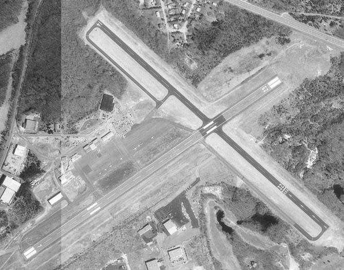
Westerly State Airport covers an area of 321 acres (130 ha) at an elevation of 81 feet (25 m) above mean sea level. It has two runways with asphalt surfaces: 7/25 is 4,010 by 100 feet (1,222 x 30 m) and 14/32 is 3,960 by 75 feet (1,207 x 23 m).
In 2005, $3.4 million in federal funding was allocated to repair and improve the main runway and taxiways. As of November 2006, improvements were finished and the main runway is open.
For the 12-month period ending June 30, 2011, the airport had 19,503 aircraft operations, an average of 53 per day: 68% general aviation, 32% air taxi, and <1% military. At that time there were 53 aircraft based at this airport: 85% single-engine, 13% multi-engine, and 2% helicopter.
Airline and destination
Scheduled airline passenger service is available to the following non-stop destination: