
OS grid reference SE096212 Post town HALIFAX Dialling code 01422 | Sovereign state United Kingdom | |
 | ||
Region | ||
West vale abby shadows over innistrad card review
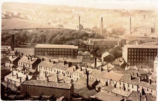
West Vale is a village in Calderdale, West Yorkshire, England. The village falls within the Greetland and Stainland parish of the Calderdale Council. It is 2.5 miles (4.0 km) south of Halifax, 2 miles (3.2 km) west of Elland and 4 miles (6.4 km) north-west of Huddersfield.
Contents
Location
West Vale is situated directly east of Greetland and is primarily based around Rochdale Road, Saddleworth Road and Stainland Road. These roads form a triangle within West Vale.
West Vale is part of Greetland and is east of Greetland. The reason it isn't called East Vale is because West Vale used to belong to be part of Elland District Council who historically 'gave' the area to Greetland. The village contains an office for UK construction, infrastructure and facilities management company Carillion PLC. It is home to Heath RUFC and Greetland CC. West Vale also boasts many hairdressers and also, a park 'Clay House Park' with the West Vale Primary School nearby.
Clay House is also on the route of the Calderdale Way. This is a 50-mile circular walk around the hills and valleys of Calderdale. A detailed route description can be found at www.crewheartsupport.co.uk/calderdaleway.
West Vale is now gaining popularity as a dining and socialising locations as after being reduced to just one pub, The Queen, The Travellers Rest has reopened and a wine bar has taken a superb space in Andy Thornton's Antique centre, with an Indian and a fish restaurant taking other units so now some evening the car park is filled by diners and drinkers! The Co-op supermarket built on the site of 'The Shears' is now the main retail outlet with two clothes shops, a large veterinary surgery, several cafes, a charity shop and two dog grooming parlours prove West Vale is now prospering. West Vale also houses the Stainland Road Medical Centre. One of the big old mills is now a booming recycling and packaging company while another one still intriguingly is filled with bales of some fibre for some niche textiles.
The closure of Elland Bridge after damage in 2015 famous Boxing Day's floods added extra traffic onto West Vale. Traffic is likely to be troubled when demolition commences of the big Horsfall's Mill complex. The mill on Stainland Road has a tall tower topped with mobile phone aerials, once cleared the site will be quite sizable and very desirable.
The old railway viaduct is a prominent feature and was closed to rail in the early 1960s but in mid 2015 was paved and opened as part of a planned long distance walkway stretching through Coley to Sowerby Bridge. Between Coley and Sowerby Bridge some impressive lakes are being constructed along the walkway.
A hidden stream called Black Brook flows through West Vale it is usually quite clear so perhaps the name dates back to ancient mining or textiles use. It starts up at Scammonden Dam, drains Greetland and is joined by the stream that drains Holywell Green and Stainland which means heavy rain can cause it to run very high and fast for a day or two. It usually runs clear enough for the small number of trout to be seen and they attract heron, gannet and mink, with dipper and kingfisher also to be seen in places where the stream is visible behind fences and walls. There are several rises of trout flies each year with the most impressive being a late spring one of very large flies that emerge on warm evenings at sunset and are spectacularly lit by the setting sun.