
Length 30.5 mi (49.1 km) Season Spring to Fall Lowest point 850 feet (260 m) | Use Hiking Trail difficulty Moderate Highest point 2,080 feet (630 m) | |
 | ||
Trailheads North: On Colton Road 0.5 miles (0.8 km) south of U.S. Route 6, near the village of AnsoniaSouth: Pennsylvania Route 414, 1.8 miles (2.9 km) south of the village of Blackwell Hazards Severe Weather, Poison ivy, Bears | ||
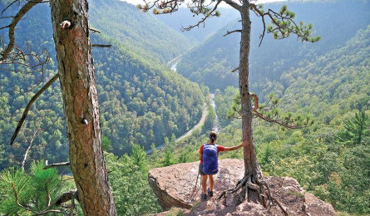
Hiking the west rim trail pa grand canyon
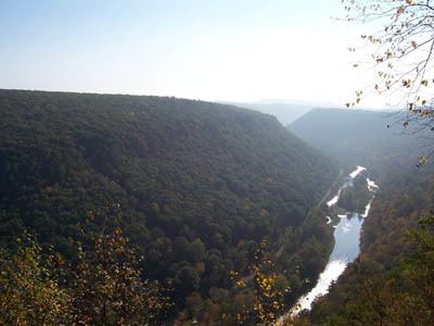
The West Rim Trail is a 30.5 mi (49.1 km) hiking trail along Pine Creek in Lycoming and Tioga Counties in north central Pennsylvania in the United States. The trail runs along Pine Creek Gorge, also known as the Grand Canyon of Pennsylvania, which is 800 feet (240 m) deep and about 2,000 feet (610 m) wide from rim to rim in the area traversed by the West Rim Trail. The trail is entirely within the Tioga State Forest and is known for its large number of vistas overlooking the gorge, which is a National Natural Landmark. The West Rim Trail was chosen by Outside Magazine as its "Best Hike in Pennsylvania" in April, 1996.
Contents
- Hiking the west rim trail pa grand canyon
- Backpacking the west rim trail pa grand canyon
- Geography
- History
- Blazes
- References
Backpacking the west rim trail pa grand canyon
Geography
The northern terminus of the trail is on Colton Road, 0.5 miles (0.8 km) south of U.S. Route 6, near the village of Ansonia. Ansonia is about 6 miles (10 km) west of Wellsboro, the county seat of Tioga County. The northern trailhead is at an elevation of 850 feet (260 m) and the trail climbs 700 feet (210 m) in 2.6 miles (4.2 km) as it heads south.
The West Rim Trail has many climbs and offers many vistas. It runs generally north-south along the west rim of the Pine Creek Gorge, hence the name. The trail is entirely on Pennsylvania State Forest lands, in the Tioga State Forest. It passes just west of Colton Point State Park, and is across the gorge from Leonard Harrison State Park. The trail runs parallel to the Pine Creek Rail Trail which follows the east bank of Pine Creek, but is some 800 feet (240 m) above it at the state parks.
The highest elevation on the West Rim Trail is at 2,080 feet (630 m), south of Gundigut Hollow. The trail is on the Allegheny Plateau and is generally at an elevation between 1,600 feet (490 m) and 1,700 feet (520 m). The steepest portion is along Lloyd Run near the southern terminus, where the elevation changes 300 feet (91 m) in just 0.25 miles (0.40 km).
Heading south, the trail drops 1,040 feet (320 m) in the last 2.0 miles (3.2 km) (this includes the steepest portion of the trail). Because of this, most hikers choose to hike from the north to the south. The southern terminus is at Rattlesnake Rocks on Pennsylvania Route 414, where Lloyd Run joins Pine Creek, 1.8 miles (2.9 km) south of the village of Blackwell. The total length of the West Rim Trail is 30.46 miles (49.02 km).
History
The Pine Creek Gorge is believed to have been formed at the end of the Wisconsin glaciation, when retreating glaciers provided large amounts of water and dammed Pine Creek's northward flow. The creek flowed south instead, carving the gorge in a few thousand years.
Portions of the trail follow old abandoned logging roads and railroad grades. These are left over from the 19th and early 20th century when the lumber industry cut down almost all the trees in the area. The state of Pennsylvania purchased the land, often at tax sales after it was abandoned and clear-cut. In the 1930s, some Civilian Conservation Corps work was done in the state forest and state parks, building recreational facilities and making roads.
The Pine Creek Gorge Natural Area was originally 8,153 acres (32.99 km2) and extended from Ansonia south to Jerry Run, and from rim to rim of the canyon, plus 300 feet (91 m) on each side. In 1968 the Pine Creek Gorge Natural Area was designated a National Natural Landmark. This was expanded to 13,100 acres (53 km2) in 1993, to include land up to Claymine Road on the east rim and West Rim, Paiter-Leetonia, and Colton Roads on the West Rim. The natural area extends 18 miles (29 km) along Pine Creek.
The West Rim Trail opened in 1982, originally as a 21 miles (34 km) long trail from the current southern terminus at Lloyd Run and Rattlesnake Rocks to the Refuge Trail. The final 9 miles (14 km) of the trail were completed in 1985, extending it to the current northern terminus near Ansonia.
Blazes
The trail is blazed using orange blazes.