
Country United States County Essex Incorporated 1817 Elevation 28 m Population 4,235 (2010) | State Massachusetts Settled 1635 Time zone EST (UTC-5) Zip code 01985 Local time Friday 9:54 PM | |
 | ||
Weather 0°C, Wind NE at 14 km/h, 97% Humidity | ||
138 indian hill west newbury massachusetts real estate homes
West Newbury is a town in Essex County, Massachusetts, United States. Situated on the Merrimack River, its population was 4,235 at the 2010 census.
Contents
- 138 indian hill west newbury massachusetts real estate homes
- Map of West Newbury MA USA
- Video of 772 main street west newbury massachusetts real estate homes
- History
- Geography
- Demographics
- Culture
- Education
- Transportation
- Notable people
- References
Map of West Newbury, MA, USA
Video of 772 main street west newbury massachusetts real estate homes
History
West Newbury was first settled in 1635 as part of neighboring Newbury. On February 18, 1819, the General Court of Massachusetts passed an act "to incorporate the town of Parsons." The initial proposals had been made in the late 18th century, but determined resistance from the town of Newbury, which had already lost Newburyport, blocked the measure for decades. On June 14, 1820, the legislature passed another act to change the name to West Newbury.
Over the last forty or so years, West Newbury has evolved from a rural farming town into an affluent community. West Newbury's status as an affluent community can be attributed to its location in Essex County. In 2006, Essex County received the dubious honor of being named number one on Forbes magazine's list of most overpriced places to live in the U.S. The magazine cited high living costs and expensive real estate as the major reasons Essex County was picked over cities with higher mean real estate values.
The town's oldest continually-operating farm is Long Hill Orchard. The farm has been active since 1896, and has a long and intriguing history. Today, in addition to the apple orchard, the farm is home to a popular Community Supported Agriculture program and farm to table dining events.
Geography
West Newbury is a part of Massachusetts' North Shore, as well as the Merrimack Valley regions of the state. It lies along the south banks of the Merrimack River, 10 miles (16 km) upstream from the Atlantic Ocean. The town is located approximately 13 miles (21 km) northeast of Lawrence and 34 miles (55 km) north of Boston. It is bordered by Merrimac and Amesbury to the north, Newburyport to the east, Newbury to the southeast, Groveland to the southwest, and Haverhill to the west. The Rocks Bridge across the Merrimack River is the only access to the northern banks of the river in town; there is no direct route into Merrimac and Amesbury.
West Newbury is separated from Newburyport by the Artichoke River and its upper and lower reservoirs. Several other rivers and brooks, including the Indian River, flow through the town. The southern corner of town is part of the Crane Pond Wildlife Management Area, and two other protected areas, the Riverbend Recreation Area and Mill Pond Recreation Area, are located in the northern part of town. The town's highest point is on Crane Neck Hill in the south of town. Significant efforts have been made by residents to maintain the rural character of the town through advocacy for the preservation of open spaces. West Newbury is well known for its many hills: Pipestave Hill, Archelaus Hill, Brake Hill, Ilsey Hill, Indian Hill, Long Hill and Meetinghouse Hill.
According to the United States Census Bureau, the town has a total area of 14.7 square miles (38.1 km2), of which 13.4 square miles (34.8 km2) is land and 1.3 square miles (3.3 km2), or 8.65%, is water.
Demographics
In 2000 the 4149 were distributed into 1,392 households, and 1,183 families. The racial makeup of the town was 98.5% White, 0.2% African American, 0.5% Asian, 0.4% from other races, and 0.4% from two or more races. Hispanic or Latino of any race were 0.7% of the population.
Of 1,392 households in 2000, 46.6% had their own children under the age of 18 living with them, 76.8% were married couples, 6.2% were a female householder with no husband present, and 15.0% were non-families. 11.9% of all households were made up of individuals and 5.2% were individuals living alone who were 65 years of age or older. The average household size was 2.98 and the average family size was 3.25.
By age, 30.0% were under the age of 18, 4.3% from 18 to 24, 27.0% from 25 to 44, 29.9% from 45 to 64, and 8.8% were 65 years of age or older. The median age was 39.6 years. For every 100 females there were 99.5 males. For every 100 females age 18 and over, there were 93.9 males.
The median income for a household in the town was $112,828, and the median income for a family was $128,050. Males had a median income of $100,670 versus $80,189 for females. The per capita income for the town was $35,323. About 2.8% of families and 3.8% of the population were below the poverty line, including 3.8% of those under the age of 18 and 9.8% of those 65 and older.
Property values in West Newbury are among the highest in the state; particularly the Newbury-Newburyport-West Newbury area, which are towns in Essex County, one of the single most expensive counties in the state.
Culture
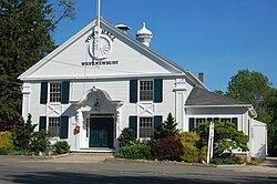
West Newbury and its residents were the models for Popperville, the setting of Virginia Lee Burton's children's story Mike Mulligan and His Steam Shovel. The town hall where the story ends is patterned after West Newbury's Old Town Hall. West Newbury also provided the geographical inspiration for the Mad Scientists' Club series of stories by Bertrand R. Brinley. Portions of John Cena's music video, "Right Now", were shot in West Newbury, with the remainder filmed at Hampton Beach, New Hampshire. In the late summer and fall of 2008, various scenes from Mel Gibson's film Edge of Darkness were shot on Church Street.
West Newbury is home to Emery House, monastery guesthouse and sanctuary of the Society of St. John the Evangelist.
There are many farms in West Newbury, including Brown Spring Farm (which was recently placed for sale) and Long Hill Orchard, both located on Main Street. A number of other farms exist in West Newbury, including Maple Crest Farm, several Christmas tree farms, and numerous horse stables and equestrian facilities. Efforts to maintain West Newbury's rural charm have been ongoing; the Town has purchased large swaths of land designated as Open Space by the West Newbury Open Space Committee.
Education
Along with neighboring Merrimac and Groveland, it is part of the Pentucket Regional School District. It also contains the Dr. John C. Page School
Transportation
Interstate 95 crosses through the eastern corner of town, with an exit lying just over the line in Newbury providing access to the town. Massachusetts Route 113 is the main road through town, roughly parallel to the contour of the Merrimack River. The town lies between the termini of two lines of the MBTA Commuter Rail, the Haverhill/Reading Line to the west and Newburyport/Rockport Line to the east. A small airstrip, Plum Island Airport (2B2), is located in neighboring Newburyport; the nearest national air service is in Boston at Logan International Airport.