
 | ||
Does apd have a suspect in the west mesa murders
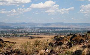
The West Mesa is an elevated landmass lying west of the Rio Grande stretching from south of Albuquerque northward to Bernalillo in the U.S. state of New Mexico. The eastern edge of the West Mesa is defined by an escarpment that borders the Rio Grande floodplain. The West Mesa also serves as the easternmost extent of the Colorado Plateau in this region. The western edge of the mesa is the Rio Puerco near the Laguna Pueblo about 20 miles (32 km) west of Albuquerque. A large portion of the West Mesa is part of Petroglyph National Monument and is bisected by Interstate 40 and Historic Route 66. Atrisco Vista (previously named Paseo del Volcan) (NM 347) runs north-south on the West Mesa, connecting I-40/US-66 to Double Eagle II Airport. There are numerous subdivisions with new homes being built on the lower portion of the West Mesa as the City of Albuquerque continues to expand further to the west. Further west on the Mesa are the mobile home communities of Pajarito, located to the south of I-40 and Lost Horizon, located about 1/2 mile north of I-40 and 3 miles west of the Paseo del Volcan interchange. The Bernalillo County Correctional Facility and the Sandia Motor Speedway are also located on the West Mesa, several miles south of Interstate 40. The National Weather Service also operates a WSR-88D NEXRAD radar site on the West Mesa near Double Eagle II Airport.
Contents
- Does apd have a suspect in the west mesa murders
- West mesa murders part one
- Subdivisions
- Locations and geographic features located at the West Mesa
- References
West mesa murders part one
Subdivisions
List of Major subdivisions in the West Mesa area of Albuquerque:
Anderson Heights, Cottonwood Height, Desert Spring Flower, Eagle Ranch, El Rancho Grande, Grande Heights, Ladera West, La Luz, Laurelwood, Los Volcanes, Montecito Estates, Paradise Greens, Paradise Hills, Rancho Sereno, Rolling Hills, Saltillo, Seville, Skies West, Stonebridge Pointe, Stormcloud, Sunrise, Taylor Ranch, The Trails, Ventana Ranch, Ventana Ranch West, Volcano Cliffs, Vista Sandia, West Gate (ADDTN 1-12), West Gate Vecinos, and West Gate Heights.
There are four high schools in the region: Atrisco Heritage High School, Cibola High School, Volcano Vista High School, and West Mesa High School.