
Region Northern Region Area 4,892 km² | ISO 3166 code GH-NP-WM Capital Walewale | |
 | ||
Time zone Greenwich Mean Time (UTC+0) | ||
Computers2ghana project walewale west mamprusi district
The West Mamprusi District is one of the twenty-six districts in the Northern Region of north Ghana. Walewale and Wulugu are the major settlements found in West Mamprusi District, the former being its capital.
Contents
- Computers2ghana project walewale west mamprusi district
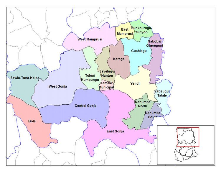
- Map of West Mamprusi Ghana
- History
- Location
- References
Map of West Mamprusi, Ghana
History
Before the creation of the 20 districts, in 1988, West Mamprusi District was part of the 48 districts that were created under the government of Ghana's decentralization and local government reform policy. The district was carved out of the old Gambaga district in the Northern Region.
Location
The districts' administrative capital can be located along the Tamale-Bolgatanga trunk road, 109 kilometres (68 mi) away from Tamale. It is boarded to the north by Builsa, Kasena-Nankana and Bolgatanga districts, in the Upper East Region ; to the south by North Gonja, Karaga, Kumbungu and Savelugu district in the Northern Region; to the west by the Sissala East and Wa East districts; and to the East by East Mamprusi district.