
Population 4,569 (2001) Southeast Te Atatu | Northwest Kumeu / Helensville Southwest Massey, New Zealand | |
 | ||
Ferry terminal(s) West Harbour Ferry Terminal | ||
6 forster place west harbour auckland new zealand
West Harbour is a suburb of Auckland, located to the west of Auckland City. It is named for its location on the western side of the Waitemata Harbour. West Harbour is under the governance of Auckland Council after the amalgamation of district Councils in 2010. Historically a suburb of the former Waitakere City territory district, however it has long been considered that this suburb does not form a part of West Auckland.
Contents
Map of West Harbour, Auckland, New Zealand
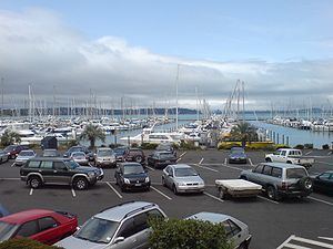
Local features include many public reserves (the most prominent being Luckens Reserve, which in 2014 received a basketball court), two local primary schools, West Harbour School and Marina View School, a Church, and farm land. West Harbour is home to Westpark Marina, a large marina catering to over 600 of private leisure boats and yachts, which was part of the route the Royal Family took during their 2014 visit. As the unique terrain of West Harbour, most of the houses have a magnificent sea view and city view, which makes the suburb become one of the exclusive suburb in Auckland City and home to hundreds of multi million houses and mansions. West Harbour has the highest median house price in Waitakere City.
Locally located State secondary schools are Massey High School, Rutherford College, Henderson High School, Liston College, Waitakere College and St Dominic's College.