
OS grid reference SP629717 Sovereign state United Kingdom Dialling code 01788 | Civil parish West Haddon Local time Saturday 12:28 AM UK parliament constituency Daventry | |
 | ||
Weather 8°C, Wind SE at 10 km/h, 83% Humidity | ||
West Haddon is a village in the Daventry district of the county of Northamptonshire, England about 11 miles (18 km) north-west of Northampton and 7 miles (11 km) east of Rugby and just off the A428 road which by-passes the village. The population of civil parish was 1,718 at the 2011 Census. The villages of West Haddon and Crick were by-passed by the A428 main road from Rugby to Northampton when the Daventry International Rail Freight Terminal (DIRFT) was built in 1996 near junction 18 of the M1 Motorway, 3 miles (4.8 km) miles west of the village.
Contents
- Map of West Haddon Northampton UK
- History
- Notable buildings
- Facilities
- Internet
- Sport
- School
- Notable residents
- References
Map of West Haddon, Northampton, UK
History
The fields of West Haddon were the location for an enclosure riot in 1765. An advertisement was made in the county newspaper for a football game that was to be played in those fields. The football game was a means to assemble a mob which tore down fences and burned them, protesting against the laws that were then being enacted that allowed wealthy landowners to lay claim to land that was once public land.
Notable buildings
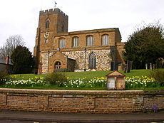
The Historic England website contains details of a total of 32 listed buildings in the parish of West Haddon, all of which are Grade II except for All Saints’ Church which is Grade I. These include:
Facilities
It also has a post Office and a Londis. There is one public house, The Crown, which was recently refurbished (The Sheaf Inn closed for business in 2013), and also The Pytchley Hotel, named after the local Pytchley hunt.
Internet
In 2003, a group of technology experts from the village and the village of Winwick grouped together to provide wireless internet for both villages, as British Telecom would not upgrade the local exchange to broadband internet. The system ran successfully until October 2004 when BT broadband was installed.
Sport
The village has many provisions for sport, with two large playing fields, used for men's football, at the north end of the village, a small children's play area, a tennis court, a pétanque area, a cricket pitch with pavilion and car park, and links to numerous countryside paths, such as the Jurassic Way. In the middle of the village there is a bowls lawn. West Haddon has many active sports clubs, such as the tennis club, 3 senior football teams, several youth football teams, a cricket team, a bowls club a petanque club and a table tennis club.
West Haddon Bowls Club is known as a friendly village club with members of all ages and experience and abilities. Set in the heart of the village we welcome new members at any time.
School
The village's primary school is West Haddon Endowed Church of England Primary School. Details of a series of reports on the school can be found in the relevant section of the Ofsted website. There were 201 pupils on the roll at the time of the inspection in January 2012.