
West coast trail the best hike in the world full documentary
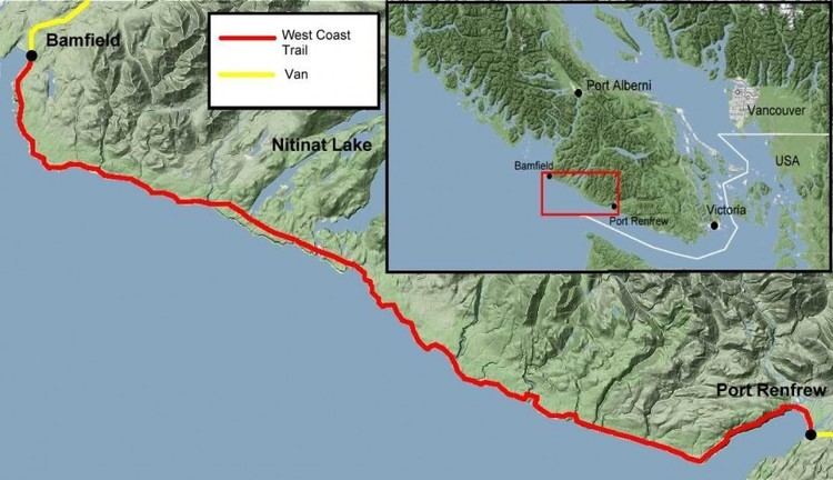
The West Coast Trail, originally called the Dominion Lifesaving Trail, is a 75 km (47 mi) long backpacking trail following the southwestern edge of Vancouver Island in British Columbia, Canada. It was built in 1907 to facilitate the rescue of shipwrecked survivors along the coast, part of the treacherous Graveyard of the Pacific. It is now part of Pacific Rim National Park and is often rated by hiking guides as one of the world's top hiking trails.
Contents
- West coast trail the best hike in the world full documentary
- West coast trail hd june 13 19 2015
- History
- Description
- Wildlife
- Winter 20062007 damage
- References
The West Coast Trail is open from May 1 until September 30. It is accessible to hikers outside this period but Parks Canada does not guarantee the accessibility of services (such as search and rescue) in the off season.
West coast trail hd june 13 19 2015
History
The West Coast Trail passes through the traditional territory of the Pacheedaht, Ditidaht, Huu-ay-aht, and Nuu-chah-nulth peoples, who have inhabited the area for over 4,000 years. Native trails, used for trade and travel, existed in the area prior to European settlement.
European use of the trail area was originally to facilitate the construction and maintenance of a telegraph line between Victoria and Cape Beale. Because of the high number of shipwrecks along this stretch of coast in the late 1800s (see Graveyard of the Pacific), the Pachena Point Lighthouse and the Dominion Lifesaving Trail were constructed.
The reefs and breakers off the west coast of Vancouver Island had long posed a serious danger to navigation, and at the start of the 20th century lifesaving infrastructure on the sparsely populated island was still primitive in spite of heavy coastal traffic that serviced the Pacific coast between San Francisco and Alaska. One source cites almost five hundred wrecks around Vancouver Island alone. Although some plans were already underway to improve the infrastructure, the public outcry which followed the wreck of the SS Valencia in January 1906 spurred the Canadian government to undertake a comprehensive plan for improvements. The resulting trail was dubbed the "Dominion Lifesaving Trail", sometimes misidentified by modern sources as "The West Coast Lifesaving Trail".
The plan included:
The trail allowed shipwreck survivors and rescuers to travel the forest making use of the telegraph line and cabins. In 1973, the trail became part of Pacific Rim National Park and has been continuously upgraded.
The current trail passes through numerous Indian Reserves (Pacheedaht: Gordon River #2 & Cullite #3; Ditidaht: Carmanah #6, Claoose #4, Wyah #3 & Tsuquanah #2; Huu-ay-aht: Masit #13). In the 1970s, a lack of regulation resulted in hikers trespassing on culturally important and environmentally sensitive First Nations archaeological sites, such as villages and refuges on Reserve lands. As a result of this trespass on the traditional territory and cultural property of First Nations living in the area, hikers are now required to remain on the trail when passing through any Reserve areas. To accommodate the growing interest in off trail historical sites the Ditidaht First Nation now offers guided adventure tours through their traditional lands.
Canadian Coast Guard Station Bamfield is still in operation and now hosts the CCG's Rigid Hull Inflatable Operator Training School.
Description
The trail starts at Bamfield near Barkley Sound and runs south to Port Renfrew on Port San Juan Bay. In 1902, Bamfield became the North America terminus of the All Red Line's Pacific submarine cable, which spanned the globe linking the British Empire. A trail was constructed to carry the line south to Victoria (and thence across Canada to link up with the Transatlantic telegraph cable at Heart's Content, Newfoundland), as well as providing telegraph service to the lighthouses at Cape Beale (on Barkley Sound) and Carmanah Point (27 km or 17 mi north of Port Renfrew, at the mouth of the Strait of Juan de Fuca).
Hikers can choose to begin the trail in Port Renfrew and travel north, or in Bamfield and travel south. The southern parts of the trail are far more challenging than the flatter area in the north. Overnight hikers must buy a permit as only a set number of people are allowed to be on the trail at any one time, however individuals are permitted to visit during the day at no expense.
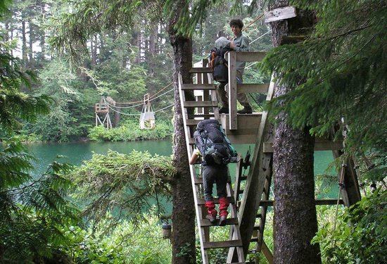
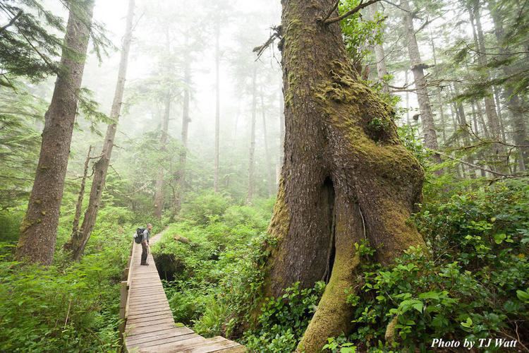
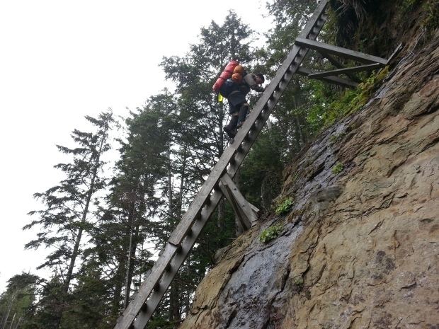
The trail itself winds through forests, bogs, slippery moss-covered ladders, climbing, repelling and beach treks. You have a choice in parts of the trail to stay in the high-lands which is very boggier, or try to make progress on the beach - slow, but easier on the feet. Keep in mind that sand is unforgiving especially with an extra 40-60 lbs on your back. The trail passes old growth trees, waterfalls, streams and thick patches of deep mud. Along the coast, the trail includes sand and pebble beaches, headlands, and exposed shelf and boulders at low tide. The trail often diverts inland to avoid dangerous surge channels and impassable headlands, where cliffs descend straight into the sea even at low tide, although in some areas the trail follows both a beach route and an inland route which hikers must select between. Portions of the beach sections can be made impassable by high tides; tide tables and maps are issued by Parks Canada staff to all hikers prior to starting the trek. In some inland areas the trail consists of a boardwalk, but care must be taken even there as the boardwalk can be in disrepair and covered with moss and mud.
The main designated campgrounds along the way feature "bear boxes" for safe storage of food, an outhouse, and a stunning view of the Pacific Ocean and Olympic Peninsula, when the sea fog is not present. This fog offers a unique perspective as the beach and sky are clear, while the view just off shore is blocked. There are also numerous smaller campsites along the trail, with varying amenities, which can offer a quieter experience away from the often crowded main campsites - as 30 people may start the trail from each direction each day, it is not unusual to find many groups of hikers spending the night at any given main campsite.
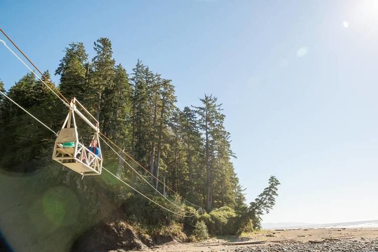
The trail is still extremely rugged and requires a high level of fitness, knowledge and skill to complete, although in the last 10 to 15 years it has been upgraded to facilitate hiking and safety for those with less experience. This has changed the nature and challenge of the trail somewhat, but has made it easier for hikers to explore the coast. It has been recommended that hikers travel in groups as a measure of safety, but some hike the trail solo. To cross the larger rivers and streams hikers must ride cable car suspensions, while smaller or slower waterways are bridged only by fallen logs, or may even require wading. There are two waterways that require a boat to cross: the Gordon River, at the southern trailhead, and the Nitinat Narrows, near the midpoint of the trail. A ferry service is operated by the local First Nation. The trail includes some three dozen ladder structures, some of them 30 feet (9.1 m) high, that hikers must ascend or descend. Hikers usually take an average of 7 days to complete the trip, allowing visitors to stop at some point for a day, although it has been run in a single day. Approximately 6,000 backpackers complete the trail every year, with one to two per cent requiring emergency evacuation due to injury, illness, or hypothermia.
There are two locations on the trail where food can be bought; the ferry operator, Doug, at Nitinat Narrows at km 32 (mile 20) has fresh seafood, a choice between salmon and crabs, baked potatoes and corn. Chez Monique's on the beach, just south of the Carmanah Lighthouse, sells a variety of burgers - beef, salmon, cod, halibut and egg+veggie. Both locations also sell pop . This is something you will find the energy to run towards after 4 or 5 days without fresh food. Lovely place with beer and snacks, such as chips, cookies and candies.
Transportation services are available at both ends of the trail via Trail Bus, or float plane. Hikers who do not wish to complete the trail can also take a water taxi at Nitinat Narrows to the other end of Nitinat Lake, but this is a time consuming process as the taxi will normally only transport hikers who wish to leave the trail after 5:00 pm as it is used before then to allow hikers to cross from north to south or the reverse and land travel is slow and tedious.
Wildlife
Wildlife that can be encountered include cougars, black bears, wolves, hummingbird, orcas and gray whales, seals, sea lions, and eagles. There are also abundant tidal pools on the beach portions, where hikers can see a variety of molluscs, sea anemones, and fish. Hikers are told how to react to possible encounters with dangerous animals (cougars, bears, wolves) at the mandatory orientation session prior to starting the trail.
During certain times of year, there is the possibility of encountering seal pups on the beach; the pups should not be approached, as the mother may then abandon the pup. All wildlife on the trail should only be viewed from a safe distance.
Winter 2006/2007 damage
In January 2007, it was revealed that intense storms during the previous weeks had severely damaged the trail. The full extent of the damage was not initially known, but an estimated 3,000 trees had been downed, a bridge and cable car were destroyed, and a serious landslide at kilometre 12 (mile 7) was discovered. In March, C$500,000 in extra funding from the federal government was announced to assist with the cleanup. The trail now features many rebuilt walkways, ladders, and bridges replacing those that were destroyed by the storm. However, as structures deteriorate quickly in the wet coastal conditions, fallen trees and slippery boardwalk are still commonly encountered.