
OS grid reference TL225165 Post town WELWYN Local time Monday 4:07 AM Postcode district AL6 | Sovereign state United Kingdom Dialling code 01438 Population 8,425 (2011 Census) | |
 | ||
Weather 8°C, Wind NW at 16 km/h, 82% Humidity Points of interest Welwyn Roman Baths, Mardley Heath, Danesbury Park, Singlers Marsh | ||
Death of the chieftain welwyn garden city england
Welwyn /ˈwɛlɪn/ is a village and civil parish in Hertfordshire, England. The parish also includes the villages of Digswell and Oaklands. It is sometimes called Old Welwyn to distinguish it from the much newer settlement of Welwyn Garden City, about a mile to the south, though some residents dislike the suggestion of inferiority or irrelevance that tends to be implied by the moniker "Old" and prefer Welwyn Village.
Contents
- Death of the chieftain welwyn garden city england
- Map of Welwyn UK
- Etymology
- History
- Historical descriptions
- Transport
- Education
- Sports
- Local points of interest
- Twinning
- References
Map of Welwyn, UK
Etymology
The name is derived from Old English welig meaning "willow", referring to the trees that nestle on the banks of the River Mimram as it flows through the village. The name itself is an evolution from weligun, the dative form of the word, and so is more precisely translated as "at the willows", unlike nearby Willian which is likely to mean simply "the willows".
Through having its name derived from welig rather than sealh (the more commonly cited Old English word for willow), Welwyn is possibly cognate with Heligan in Cornwall whose name is derived from helygen, the Cornish word for willow that shares a root with welig.
The nearby modern village of Digswell (around Welwyn North railway station) was originally called 'High Welwyn' when first developed at the beginning of the 20th century.
History
Situated in the valley of the River Mimram, Welwyn has hosted human activity since the Palaeolithic with stone tools from that era having been found alongside the river and further inland across the area. Settlement across the area seems to have become established during the Bronze Age according to various recovered artefacts and crop marks left by round barrows and burial mounds from that period.
Iron Age remnants have not been detected until the Late Iron Age, with various local chieftain burials dated to the 1st Century BC gaining national prominence. The Belgae Celtic culture colonised much of South-Eastern England in the 1st century BC, with Welwyn in the area believed to have been settled by the Catuvellauni tribe. In Graham Robb's book "The Ancient Paths" there is a suggestion that Welwyn lay on a late-Celtic highway running in the direction of the summer solstice angle straight from Bury St Edmunds to Salisbury via the Catuvellauni headquarters at Verlamion outside modern-day St Albans. Separately, it can be shown that the line of the Roman road through Welwyn (see below) is in a direct alignment with the pre-Roman Belgic tribal centres of Verlamion (for the Catuvellauni) and Venta Icenorum for the Iceni tribe.
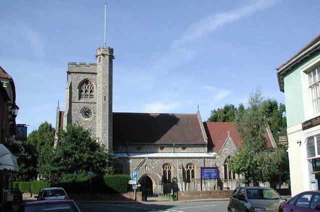
Following the Roman invasion, Welwyn was settled by the Romans. The area was marshy in times past, and the settlement of Welwyn was a known fording point across the river since at least Roman times when the Roman road through the village was laid out, leading to the establishment of the settlement around the road and the ford. Many Roman artifacts have been found in and around the village, including the remains of several Roman villas close by. The Welwyn Roman Baths (the remains of a third-century Roman bath house) have been preserved and are open to the public. One particular excavation revealed a large Roman cemetery very close to the site of the current church, which itself is known to date back to at least Saxon times (see below). The church lies directly alongside the route of the Roman road.
Welwyn was at the heart of the territory of the Anglo-Saxon Tewingas tribe and was the site of an early minster church. In 1990, a proposal was made to rename the village as "Welwyn Minster" to shake off the unpopular "Old" name.
The massacre on St. Brice's day on November 13, 1002, when the Saxons turned on their newly settled Danish neighbours, is stated to have commenced near Welwyn.
A Norman church was built on the site of the Saxon church about 1190. The nave of the present church (St Mary's), was built in the 13th century, the chancel arch being the most obvious early structure. There are two medieval corbels at the east end of the south aisle. Patronage of the church passed through several hands until in 1549 it was sold to the Wilshere family, who lived at The Frythe until relatively recently.
Much later, in the 17th century, as it lies on the old Great North Road, it became an important staging post and a number of coaching inns remain as public houses. After the Great Northern Railway by-passed the village due to the objections of local landowners, Welwyn became less important. Having previously been seen as a town on par with Hatfield and Stevenage, it gradually was seen as a village. The 20th century brought major expansion to the area, as estates to the south, west and north of the village were built up.
Historical descriptions
Despite this long history, at the beginning of the 20th century Welwyn was regarded as a sleepy backwater. One writer wrote that Welwyn, a small town in the Maran Valley, can show little of interest beyond many quaint cottages, and the church.
In 1870-72, John Marius Wilson's Imperial Gazetteer of England and Wales described Welwyn thus: WELWYN, a village, a parish, and a sub-district, in Hatfield district, Herts. The village stands on the river Maran, 1¼ mile W of the Great Northern railway, and 5 N of Hatfield; carries on shoe-making and wool-stapling; consists chiefly of two well built streets; and has a head post-office,‡ a r. station with telegraph, two hotels, a police station, a good ancient church, two dissenting chapels, a large national school, an education charity, a workhouse, and charities for the poor £26.—The parish includes Woolmer-Green hamlet, and comprises 2,987 acres. Real property, £7,044. Pop., 1,612. Houses, 320. The property is much subdivided. Danesbury and Frythe are chief residences. The living is a rectory in the diocese of Rochester. Value, £665.* Patron, All Souls College, Oxford. Dr. Young was rector, and wrote here his "Night Thoughts." A national school is at Woolmer-Green, and is used as a chapel of ease.—The sub-district contains 4 parishes, and is a poor-law union. Acres, 6,457. Pop., 2,21 1. Houses, 439.
A lengthier entry is given in William Page's 1912 History of the County of Hertford.
Transport
Welwyn was noted for its congestion since the beginning of the 20th century and in 1927 got what is claimed to be the first by-pass in Britain. The A1 was upgraded to motorway standards north of Welwyn in the 1960s and in 1973 the motorway was extended south past the village, by-passing the existing by-pass. Today the village is the point where the 6-lane motorway merges into 4-lanes and is the site of extensive traffic jams in the evening peak. A decade ago there were extensive plans to widen the whole road through the area to 8 lanes, and upgrade the existing junction to create a long one-way system running the length of the village. These plans were shelved, but recently plans to provide a climbing lane at least on the section north of the village have been discussed.
Buses are provided by Arriva and Centrebus, with some assistance from Hertfordshire County Council. Arriva's 300/301 Centraline service links Welwyn to the major nearby towns of Stevenage, Welwyn Garden City, Hatfield, St Albans and Hemel Hempstead, as well as neighbouring villages Woolmer Green and Knebworth. The 301 additionally connects both the nearby hospitals in Stevenage and Welwyn Garden City, while the 300 provides a direct link to recreational areas such as Stanborough Lakes in Welwyn Garden City and Verulamium Roman town in St Albans. Buses run every 15 minutes Monday-Friday, every 20 minutes Saturday, and hourly on Sunday. Additional bi-hourly service 314 is provided by Centrebus, connecting Welwyn to Codicote and Hitchin.
Green Line Coaches 797 stops on the by-pass, providing an hourly direct link to areas of North London and the West End.
The nearest railway station is Welwyn North railway station in the nearby village of Digswell, about a mile east from the village. Trains are operated by First Capital Connect and run every 30 minutes Monday to Saturday south to London and north to Hitchin and Stevenage, with an hourly service to Letchworth and Cambridge and to Peterborough. On Sundays an hourly service operates from London to Cambridge only. There is no bus link to the station, although buses do link to nearby Welwyn Garden City railway station.
Education
There are two state schools in Welwyn and one independent school.
The larger state school is Welwyn St. Mary's Church of England Primary School, situated off London Road which takes children aged between 4 and 11 years of age (Reception to Year 6). Originally built in 1940 as a secondary school, the school was later converted to a primary school. The second is Oaklands Primary School, which incorporates Acorns Preschool and Playgroup.
There is also Tenterfield Nursery School which is situated on London Road close to the primary school. It takes children aged 3 to 4 years of age.
Secondary state education is provided through schools in nearby towns, such as Monks Walk School, in Welwyn Garden city, and Stanborough School near Stanborough Lakes.
There is an independent all-ages (nursery through to sixth form) coeducational school on the eastern outskirts of Welwyn called Sherrardswood School.
Sports
There is a tennis club, a sports & social club, a bowls club and a football club. There is a cricket pitch in the village, though this is part of Welwyn Garden City Cricket Club rather than a village-only club.
Local points of interest
The village has a brief association, celebrated by a blue plaque on a building on Church Street, with Vincent van Gogh, who visited his sister (having walked from London) while she was staying in Welwyn.
In the fields surrounding the nearby Danesbury House, now converted into accommodation, is a dilapidated and neglected former fernery designed by Anthony Parsons (then gardener for the Danesbury Estate) and constructed by the second James Pulham of James Pulham and Son in 1859. It was built in a small chalk pit in the grounds of Danesbury Park and has a fine view across the valley - sadly now occupied by the A1(M) motorway. In its day it was well admired, with one W. Robinson (writing in "The English Flower Garden", published in 1883), stating that "In the home counties there is probably not a better fernery than at Danesbury."
On the outskirts of Welwyn are the remains of a 3rd-century Roman bath-house, which was once part of the Dicket Mead villa. The villa and its bath-house were discovered by local archaeologist Tony Rook in the 1960s and subsequently excavated by him and a team of archaeologists and volunteers from Welwyn Archaeological Society. The remains of the bath-house are now preserved in a vault which is underneath the A1 motorway. The site is now run by Welwyn Hatfield Museum Service and is open to the public from 2.00pm-5.00pm on Saturdays and Sundays and bank holidays from January to November. It is also open in Hertfordshire school holidays everyday 2.00pm-5.00pm. Admission £2.50 for adults and children free.
Between 1928 and 1951 Welwyn Studios operated in the town, mainly providing supporting features. However, like Welwyn Components (another apparently eponymous business), Welwyn Studios was actually located in Welwyn Garden City.
Twinning
Welwyn is twinned with a village in France, Champagne-sur-Oise. The connection is organized (at the Welwyn end) by the Welwyn Anglo-French Twinning Association (WAFTA). The twinning started in 1973 as a result of a visit by the then headmaster and pupils of St Mary’s School in Welwyn, who went to Champagne-sur-Oise and set up a cultural association that has flourished ever since.
Coincidentally, Champagne-sure-Oise is in the departement of Val-d'Oise which is a near neighbour of the departement of Marne, whose main river of the same name is believed to have been the origin of the alternative name of Welwyn's Mimram river - the Maran. This connection was brought about by a migration of the Catalauni, the Belgic tribe from the Champagne region of France, into England stretching north of the Thames from London, where the tribe was known as the Catuvellauni. In that respect, WAFTA has resurrected a twinning link that was first forged nearly 2000 years previously.