
Population 356 (2011) Local time Monday 2:01 AM | OS grid reference SK983567 Sovereign state United Kingdom | |
 | ||
Weather 9°C, Wind W at 19 km/h, 77% Humidity UK Parliament Sleaford and North Hykeham (UK Parliament constituency) | ||
Wellingore is a village and civil parish in the North Kesteven district of Lincolnshire, England. The population of the civil parish at the 2011 census was 356. It is situated on the A607 road, approximately 12 miles (19 km) south from Lincoln. It conjoins the village of Navenby to the north. The Viking Way traverses through the village, passing from the side of the cliff edge to Ermine Street.
Contents
Map of Wellingore, Lincoln, UK
Population
In 1801 there was a resident population of 559, which peaked to 943 in 1861. In the 1971 Census there were 618 people recorded.
Buildings in Wellingore
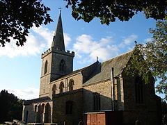
Wellingore is an attractive village with many of the older houses built in the local limestone. Wellingore was the first village in North Kesteven to be designated a Conservation Area in February 1971. The following buildings are of particular interest:
RAF Wellingore
RAF Wellingore opened in 1935 and operated for ten years until it was decommissioned in 1945. It originally opened in 1917 as RFC Wellingore Heath. The control tower was demolished, but several pillboxes and the Battle HQ building still exist.