
Founded 1851 Largest city Fort Dodge Population 37,044 (2013) Congressional district 4th | Named for Daniel Webster Time zone Central: UTC-6/-5 County seat Fort Dodge Unemployment rate 4.3% (Apr 2015) | |
 | ||
Website www.webstercountyia.org Cities Fort Dodge, Gowrie, Duncombe, Otho, Lehigh, Callender University Iowa Central Community College Points of interest Oleson Park Pool, Brushy Creek State Rec, Fort Museum Historical, Kennedy Park, Loomis Park | ||
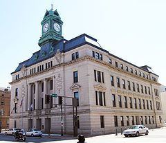
National register of historic places listings in webster county iowa top 5 facts
Webster County is a county in the U.S. state of Iowa. As of the 2010 census, the population was 38,013. The county seat is Fort Dodge. The county was established January 15, 1851 and named after Daniel Webster, an American statesman.
Contents
- National register of historic places listings in webster county iowa top 5 facts
- Map of Webster County IA USA
- Geography
- Major highways
- Adjacent counties
- 2010 census
- 2000 census
- Census designated place
- Unincorporated communities
- Population ranking
- Notable people
- References
Map of Webster County, IA, USA
Webster County comprises the Fort Dodge, IA Micropolitan Statistical Area.
Geography
According to the U.S. Census Bureau, the county has an area of 718 square miles (1,860 km2), of which 716 square miles (1,850 km2) is land and 2.8 square miles (7.3 km2) (0.4%) is water.
Major highways
Adjacent counties
2010 census
The 2010 census recorded a population of 38,013 in the county, with a population density of 53.1479/sq mi (20.5205/km2). There were 17,035 housing units, of which 15,580 were occupied.
2000 census
As of the census of 2000, there were 40,235 people, 15,878 households, and 10,304 families residing in the county. The population density was 56 people per square mile (22/km²). There were 16,969 housing units at an average density of 24 per square mile (9/km²). The racial makeup of the county was 93.39% White, 3.39% Black or African American, 0.30% Native American, 0.66% Asian, 0.02% Pacific Islander, 1.10% from other races, and 1.15% from two or more races. 2.35% of the population were Hispanic or Latino of any race.
There were 15,878 households out of which 30.20% had children under the age of 18 living with them, 51.80% were married couples living together, 9.50% had a female householder with no husband present, and 35.10% were non-families. 30.30% of all households were made up of individuals and 13.10% had someone living alone who was 65 years of age or older. The average household size was 2.38 and the average family size was 2.97.
In the county, the population was spread out with 24.50% under the age of 18, 11.10% from 18 to 24, 25.50% from 25 to 44, 21.60% from 45 to 64, and 17.40% who were 65 years of age or older. The median age was 38 years. For every 100 females there were 100.30 males. For every 100 females age 18 and over, there were 98.20 males.
The median income for a household in the county was $35,334, and the median income for a family was $43,772. Males had a median income of $31,047 versus $23,042 for females. The per capita income for the county was $17,857. About 6.70% of families and 10.00% of the population were below the poverty line, including 12.30% of those under age 18 and 7.00% of those age 65 or over.
Census-designated place
Unincorporated communities
Population ranking
The population ranking of the following table is based on the 2010 census of Webster County.
† county seat