
Type Reservoir, Lock Surface elevation 149 m Mean depth 4.6 m Cities Webbers Falls | Primary inflows First flooded December 1970 Area 46.94 km² Year built January 1965 Inflow source Arkansas River | |
 | ||
Managing agency U.S. Army Corps of Engineers Surface area 11,600 acres (4,700 ha) | ||
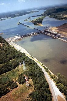
Webbers Falls Lake, also known as Webbers Falls Reservoir, is a reservoir created by a lock and dam on the Arkansas River in Muskogee County, Oklahoma. The normal elevation is 490 feet (150 m). It has 157 miles (253 km) of shoreline and a surface area of 11,600 acres (47,000,000 m2). The drainage area of the lake is 97,033 square miles (251,310 km2). It is an integral part (Lock and Dam No. 16) of the McClellan-Kerr Arkansas River Navigation System, which was completed in 1971.
Map of Webbers Falls Lake, Oklahoma 74403, USA
The lock and dam are about 3 miles (4.8 km) from the town of Webbers Falls, Oklahoma. There is an observation platform and visitor facility at the lock and dam, where visitors can view the operation of the locks during passage of river craft.
The project was authorized by Congress in the River and Harbor Act July 4, 1946, and amended by the Flood Control Acts of 1948 and 1950. Construction began in January 1965 and became operational for navigation in December 1970.