
Length 70 mi (113 km) Season All year | ||
 | ||
Trailheads Walbury Hill in West BerkshireEmsworth in Hampshire | ||
The Wayfarer's Walk is a long distance footpath in England from Walbury Hill, Berkshire to Emsworth, Hampshire.
Contents
Map of Wayfarer's Walk, Alresford SO24 9DF, UK
The footpath can be walked in either direction. The north-west end is at the car park on top of Walbury Hill, near to the landmark Combe Gibbet, and the south-east end is Emsworth town square.
The footpath approximates an ancient route that might have been used by drovers taking cattle for export. It passes through the towns of New Alresford, Droxford, Hambledon, Havant and Emsworth and the villages of North Oakley, Deane, Dummer, Brown Candover, Abbotstone, Cheriton, Hinton Ampner, Kilmeston, Soberton, and Denmead.
By the path is a memorial to the first flight of Geoffrey de Havilland. The footpath also passes close to Watership Down, Hampshire.
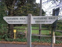
The footpath is waymarked by metal and plastic disks found attached to wooden and metal posts, trees and street furniture. It has also spawned several circular routes that use sections of the main footpath. These are also waymarked.
This route is shown as a series of green diamonds on Ordnance Survey 1:25,000 maps and as a series of red diamonds on Ordnance Survey 1:50,000 maps.
Walbury Hill is also the start of the Test Way and is the start of the Combe Gibbet to Overton 16 Mile Trail Race, the first 11 miles of its route being on Wayfarer's Walk.
Places of interest
The following places of interest, hillfort sites and hills can be found along the length of the Walk (listed from southeast to northwest):
Map
These maps show the footpath in relation to nearby major roads. Maps are not on the same scale.