
Length 49 mi (79 km) Season All year | ||
 | ||
Trailheads Walbury Hill in West BerkshireEling in Hampshire | ||
The Test Way is a 49 miles (79 km) long-distance footpath in England from Walbury Hill in West Berkshire to Eling in Hampshire.
Contents
Map of Test Way, Stockbridge SO20, UK
The northern end of the footpath starts in the car park on Walbury Hill. It passes through the towns of Romsey and Totton and the villages of Linkenholt, Ibthorpe, Hurstbourne Tarrant, St Mary Bourne, Longparish, Forton, Wherwell, Chilbolton, Stockbridge, Horsebridge and Mottisfont. The southern end of the footpath is at Eling Quay.
The trail also passes alongside Horsebridge railway station. Much of the route between Kimbridge and Chilbolton follows the route of the former Andover and Redbridge Railway.
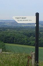
The entire route is waymarked by metal and plastic disks found attached to wooden and metal posts, trees and street furniture. There are several wooden 'finger' signs along the route that countdown the number of miles along the footpath in both directions.
This route is shown as a series of green diamonds on Ordnance Survey 1:25,000 maps and as a series of red diamonds on Ordnance Survey 1:50,000 maps
Walbury Hill is also the start of the Wayfarers Walk.
Places of interest
The following places of interest and hills can be found along the length of the Test Way, listed from Walbury Hill:
The route
These maps show the footpath in relation to nearby major roads. Maps are not on the same scale.