
Country United States County Union Time zone Eastern (EST) (UTC-5) Local time Sunday 11:01 AM Population 11,295 (2013) | Elevation 686 ft (209 m) Area code(s) 704 Zip code 28173 | |
 | ||
Weather 17°C, Wind SW at 3 km/h, 39% Humidity | ||
Waxhaw is a town located in Union County, North Carolina. The population was 9,859 according to the 2010 Census.
Contents
- Map of Waxhaw NC 28173 USA
- Geography
- History
- Demographics
- Public elementary schools
- Public middle schools
- Public high schools
- Private schools
- Special activities
- References
Map of Waxhaw, NC 28173, USA
Geography
Waxhaw is located at 34°55′42″N 80°44′41″W (34.928201, -80.744835). Stephen Maher is the current mayor of the Town of Waxhaw.
According to the United States Census Bureau, the town has a total area of 11.54 square miles (29.9 km2).Waxhaw is located north of Lancaster, South Carolina and lies about twelve miles south of the Charlotte city limit.
Waxhaw is located in the historic region called the Waxhaws and named after the indigenous Native American tribe that lived there prior to colonial settlement. Waxhaw is in the Piedmont region of North Carolina, which is a wooded area with rolling hills. This region is where gold was first discovered in the United States. The Howie Gold Mine is not far from the city limits.
History
Originally called the Wysacky, the community was settled by European-Americans in the mid-eighteenth century. Most settlers were of German and Scots-Irish origin. Settlers became subsistence farmers and were known for being independent. Andrew Jackson, the seventh President of the United States, was born nearby in 1767. There is some disagreement as to which of the Carolinas was his birthplace because of the proximity of the border.
The arrival of the railroad in 1888 created access to the markets of Atlanta and helped the town reach prosperity. The railroad tracks were laid through the center of town to show the importance of the railroad system to the community. The railroad remains in the center of town and is now bordered by a green grassy strip that divides the rows of stores on each side.
Beginning in the late 19th century, the community began to develop cotton mill factories for manufacturing textiles. The railroad helped increase access for its products. Cotton manufacturing was important to the region through the 1940s. Postwar changes in the economy, with shifts of the textile industry to jobs to other areas and out of the country, required the community to adapt to new conditions.
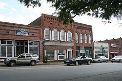
Waxhaw has evolved as an antique and fine dining center. Its Small Town Main Street committee is working on an integrated approach to developing and marketing the historic center of town. Waxhaw currently has dozens of specialty shops and dining restaurants. Restaurants located in town range from mom & pop restaurants to fine dining bistros. The Waxhaw Historic District is on the National Register of Historic Places. It includes retail businesses as well as architecturally significant houses near the center of town. Also listed is the Pleasant Grove Camp Meeting Ground.
Residents and town officials are working on additional improvement plans. In the downtown area, there is a town park and a skate park for youths. New housing has been built along NC 75 to the east and west of town, as well as NC 16 (Providence Road) to the north.
Near Waxhaw is Cane Creek Park, a 1,050-acre (4.2 km2) park, featuring scenic areas and recreation activities. The facility, on Harkey Road south of Waxhaw, was a cooperative venture between Union County, the Union Conservation District, and the Soil Conservation Service of the U.S. Department of Agriculture.
Demographics
As of the census of 2010, there were 9,859 people, 3,242 households, and 2,626 families residing in the town. For the population density, there were 854.0 people per square mile (329.95/km²) and 3,517 housing units. As for the racial makeup of the town, there were 78.1% White, 11.00% African American, 2.1% from two or more races, 2.0% Asian, and 0.04% Native American. The Hispanic or Latino of any race was 6.4% of the population.
There were 3,242 households out of which 41.8% had children under the age of eighteen living with them, 81.0% were married couples living together, 10.5% had a female householder with no husband present, and 19.0% were non-families. The average household size was 3.04 and the average family size was 3.41.
In the town, the population age range was from 34.6% under the age of 18, 3.1% from 20 to 24, 32.3% from 25 to 44, 21.2% from 45 to 64, and 7% who were 65 years of age or older. The median age was 34.5 years. For every 100 females there were 93.6 males. For every 100 females age 18 and over, there were 88.8 males.
The median income for a household in the town was $73,188. The per capita income for the town was $27,949. The percentage of people below the poverty line was 8.9%.