
Time zone Central (CST) (UTC-6) Population 578 (2013) | Elevation 774 ft (236 m) Area code(s) 715 & 534 Local time Sunday 8:28 AM | |
 | ||
Weather 13°C, Wind S at 10 km/h, 66% Humidity | ||
How to say or pronounce usa cities wausaukee wisconsin
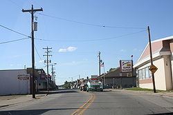
Wausaukee is a village in Marinette County, Wisconsin, in the United States. The population was 575 at the 2010 census. The village is part of the Marinette, WI–MI Micropolitan Statistical Area.
Contents
- How to say or pronounce usa cities wausaukee wisconsin
- Map of Wausaukee WI USA
- Geography
- History
- 2010 census
- 2000 census
- Notable residents
- References
Map of Wausaukee, WI, USA
Geography
Wausaukee is located at 45°23′N 87°57′W (45.3767, -87.9561).
According to the United States Census Bureau, the village has a total area of 1.41 square miles (3.65 km2), of which, 1.40 square miles (3.63 km2) of it is land and 0.01 square miles (0.03 km2) is water.
History
Wausaukee is a Menominee word that means “river in the hills.” The town was started in 1863 by John S. Monroe, who bought 160 acres of land from business tycoon Lars Kovala and built a mill to supply the railroads with lumber for bridges and culverts. His first building was a log cabin home that was also used to board the mill workers. Eventually as the town grew more and people moved in, his log cabin grew into an Inn and was the only public eating establishment north of Green Bay.
On August 19, 2011 at 4:45pm, a F-1 Class tornado struck Wausaukee. An F-1 Class tornado is one with wind speeds 86–110 miles per hour. One fatality was recorded.
2010 census
As of the census of 2010, there were 575 people, 275 households, and 145 families residing in the village. The population density was 410.7 inhabitants per square mile (158.6/km2). There were 325 housing units at an average density of 232.1 per square mile (89.6/km2). The racial makeup of the village was 95.7% White, 1.2% Native American, 0.2% Asian, 0.5% from other races, and 2.4% from two or more races. Hispanic or Latino of any race were 2.8% of the population.
There were 275 households of which 25.8% had children under the age of 18 living with them, 33.5% were married couples living together, 12.7% had a female householder with no husband present, 6.5% had a male householder with no wife present, and 47.3% were non-families. 41.8% of all households were made up of individuals and 24% had someone living alone who was 65 years of age or older. The average household size was 2.09 and the average family size was 2.78.
The median age in the village was 43.3 years. 22.8% of residents were under the age of 18; 7.8% were between the ages of 18 and 24; 21.6% were from 25 to 44; 25.2% were from 45 to 64; and 22.4% were 65 years of age or older. The gender makeup of the village was 48.7% male and 51.3% female.
2000 census
As of the census of 2000, there were 572 people, 251 households, and 150 families residing in the village. The population density was 402.4 people per square mile (155.5/km²). There were 294 housing units at an average density of 206.8 per square mile (79.9/km²). The racial makeup of the village was 96.50% White, 0.87% Black or African American, 22.22% Native American, 0.17% from other races, and 1.22% from two or more races. 0.87% of the population were Hispanic or Latino of any race.
There were 251 households out of which 28.7% had children under the age of 18 living with them, 43.0% were married couples living together, 13.5% had a female householder with no husband present, and 40.2% were non-families. 35.9% of all households were made up of individuals and 20.3% had someone living alone who was 65 years of age or older. The average household size was 2.27 and the average family size was 2.97.
In the village, the population was spread out with 26.2% under the age of 18, 7.2% from 18 to 24, 22.9% from 25 to 44, 21.9% from 45 to 64, and 21.9% who were 65 years of age or older. The median age was 40 years. For every 100 females there were 84.5 males. For every 100 females age 18 and over, there were 75.8 males.
The median income for a household in the village was $25,313, and the median income for a family was $35,833. Males had a median income of $30,313 versus $20,417 for females. The per capita income for the village was $13,098. About 17.5% of families and 23.0% of the population were below the poverty line, including 36.8% of those under age 18 and 11.3% of those age 65 or over.