
Proposer NZ Transport Agency Start date Late 2011 Cost estimate $1.7 billion | Type Road & tunnel Completion date June 2017 Owner NZ Transport Agency Status Under construction | |
 | ||
Stakeholders Government of New Zealand, NZ Transport Agency, Auckland Council, Campaign for Better Transport, Cycle Action Auckland, Friends of Oakley Creek, North West Community Association, various further community groups and submitters Road Western Ring Route (New Zealand State Highway 20) | ||
Finishing touches being put on 1 4b auckland waterview connection tunnels
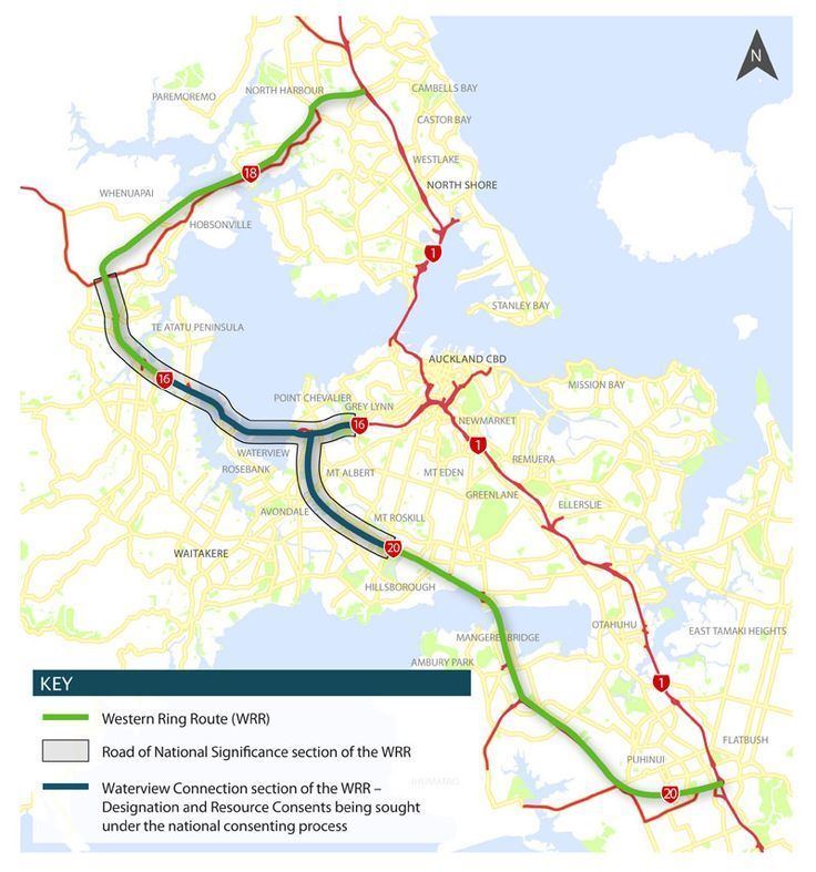
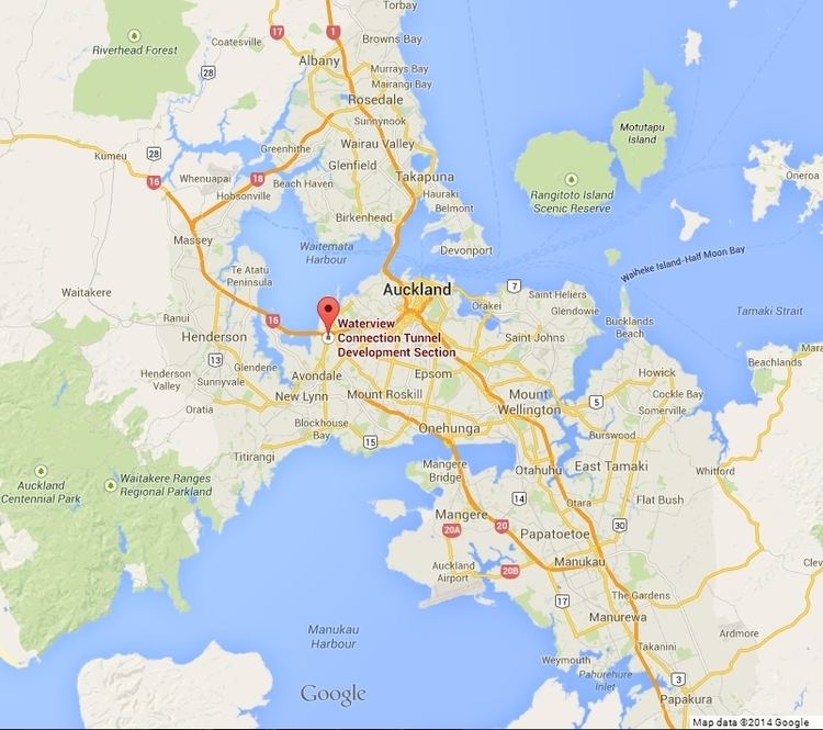
The Waterview Connection is a motorway section under construction through west/central Auckland, New Zealand. It will connect State Highway 20 in the south at Mt Roskill to State Highway 16 in the west at Point Chevalier, and is a part of the Western Ring Route. It was formerly known as the SH20 Avondale extension.
Contents
- Finishing touches being put on 1 4b auckland waterview connection tunnels
- Planning history
- Routes considered
- Bored tunnels preferred
- Public private partnership investigation
- Notice of requirement deferred
- Request to reconsider Rosebank route
- Cost of bored tunnels questioned
- Combination tunnel method announced
- Combined surfacetunnel alignment confirmed
- Final alignment confirmed
- Road of National Significance Fast tracking
- Process and hearing
- Board of Inquiry decision
- Start of enabling works
- Contract awarded
- Proposal to relocate northern vent stack
- Enabling Works JanuaryJune 2012
- Southern Portal works
- Northern Portal works and Great North Road Interchange
- Tunnelling
- Opening
- Mitigation and related projects
- AvondaleSouthdown railway line
- Passive Open Space
- Active Open Space
- Walkways and cycleways
- Maioro Street to New Lynn
- References
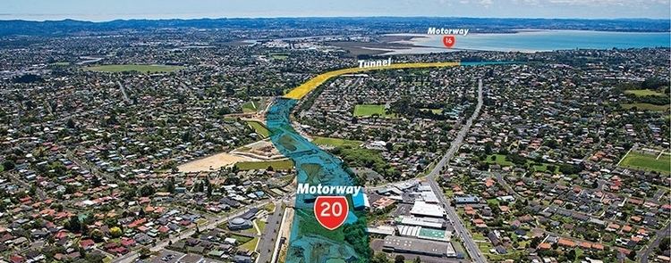
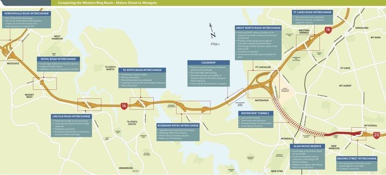
The Waterview link will be 4.5 km long, of which 2.5 km will be in bored twin tunnels, with three lanes in each tunnel. Upon opening, the two tunnels will supersede the Lyttelton Road Tunnel as New Zealand's longest road tunnels. By 2026, the link is expected to carry 83,000 vehicles a day.
On 21 December 2009, a final alignment and extended tunnel option was announced requiring 205 houses to be bulldozed. From late 2010 onwards, the consent process for the motorway proposal proceeded with a new 9-month fast-track board of inquiry format enabled by changes to the Resource Management Act. Significant upgrades and widening (additional traffic lanes) on State Highway 16 from St Lukes Road to Te Atatu were rolled into the approvals process. While the majority of this widening occurs on the Western Ring Route, the widening is not part of the Waterview Connection, except in a legal/approvals sense.
In mid-2011, the board of inquiry granted consent, which could not be appealed except on points of law (and was not appealed by any parties). The decision was generally greeted positively, as it allowed work to proceed on the project, and as the board directed significant environmental mitigation over and above what the NZ Transport Agency (NZTA) had originally proposed for the affected communities.
The New Zealand Transport Agency intends to complete the project and open the tunnels and interchange in early 2017. It will complete the Western Ring Route and will be the last section of SH20, completing an alternative north-south highway link that bypasses the inner city.
Planning history
The project has had an extensive planning history, with the earliest consultation having occurred in 2000, though the proposal for a route roughly in the area dates from much earlier.
Routes considered
Several routes were considered, all being variations of either a connection to SH16 along the Rosebank Peninsula (e.g. AR1, AR3) or at the Great North Road interchange at Waterview (e.g. AW1, AW4). It was generally assumed that below-ground construction would be required where AR3 passed through Avondale Heights, to a maximum depth of 41 m. On the basis of technical and environmental assessments, the AR3 and AW4 route options were dismissed.
Transit New Zealand selected the Waterview connection as its preferred route, with the support of the Auckland City Council and Waitakere City Council, over the Rosebank option, which was the preferred route of the Auckland Regional Council. The previous AW1 and AW4 routes favoured a New North Road interchange with ramps facing south, and full connections at the Waterview interchange. The preferred route was announced with a Great North Road interchange replacing New North Road and no southbound access at Waterview. This proved unpopular with local residents, and it was considered unlikely a bored tunnel could accommodate an interchange because of its depth.
Bored tunnels preferred
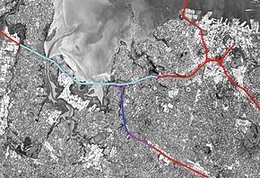
On 7 February 2008, bored tunnels were announced as Transit's preferred option. The NZ Transport Agency's preferred option was a pair of two-lane tunnels costing $1.89 billion, rather than a pair of three-lane tunnels costing $2.14 billion. NZTA's traffic modelling indicated that two-lane tunnels would reach capacity within 10 years of operation. Map of Tunnel Route
Transit NZ's board resolved to seek a designation over land for a $1.89 billion pair of motorway tunnels through Waterview. The board called for a report from officials on managing fumes from the tunnel "to benchmark the proposed approach incorporated in the design work to date against current international best practice". In response to submissions questioning the adequacy of just two traffic lanes running in each direction, it sought a comparative assessment of the operational performance and costs of providing three-lane tunnels, initially estimated at $2.14 billion.
Tunnels are not much more expensive than a far more disruptive option of a surface route combined with limited sections of "cut and cover" trenches costing $1.7 billion. A full surface option would have been disadvantaged by the need to run the motorway under or over two rail corridors, several busy arterial roads and Oakley Creek.
Public-private partnership investigation
The government set up a joint public-private sector steering group to investigate the feasibility of a public-private partnership (PPP) as a procurement method for the Waterview Connection Project, evaluating the PPP alongside a conventional public sector procurement method to determine how the two methods compared in terms of value for money. The steering group had as an independent chairperson, Sir Brian Elwood, and reported directly to the Ministers of Finance and Transport. Its report to the Government was expected by the end of June 2008.
It was announced on 26 August 2008 that the steering group had advised the Government that a public-private partnership (PPP) was the best way of building the new $2 billion section of the city's Western Ring Route. Finance Minister Michael Cullen said a PPP, which would mean tolls of about $2 a trip, was looking "pretty positive". Transport Minister Annette King said the report identified several critical factors that would need to be met for the project to be successful, and she had ordered officials to do more work before the Government committed to a PPP. Treasury, Transport Ministry and New Zealand Transport Agency officials were to report back to ministers by October or early November. "Once this work is done Cabinet will be able to make some firm decisions on how to progress Waterview."
Notice of requirement deferred
The NOR, which had been expected to be lodged by the end of November 2008, was deferred. The NZTA stated that they would keep working towards lodgement while the technical issues were worked through. The following points were raised:
Request to reconsider Rosebank route
The ARC requested NZTA to reconsider whether the proposed Waterview Connection was the most cost-effective way of completing the Western Ring Road, with a reconsideration of the costs and benefits of the alternative Rosebank route.
Cost of bored tunnels questioned
In 2009, the CEO of Federated Farmers, Conor English (brother of the Finance Minister of the same period, Bill English), announced that Federated Farmers wanted the government to review the tunnelling with a view to cancelling it. He argued in an editorial that the project represented a "tunnel with no hill", costed at that time at about $1.9 billion or about $600 million a kilometre. Therefore, the motorway should instead be built as a surface road, and the savings invested into water storage projects benefitting farming.
On 30 January 2009 Transport Minister Steven Joyce announced his concern with the $3.16 billion cost (including financing costs of more than $500 million and an upgrade of the nearby Northwestern Motorway for $240 million) of three-lane tunnels. Because he was "not comfortable" with the idea of reducing the tunnels to two lanes with no ability to enlarge them for future traffic demand, he gave officials until April to review all options for a connection of State Highway 20 to the Northwestern Motorway at Waterview, including a potentially disruptive surface route through Mt Albert and previously discarded "cut and cover" proposals. He was unable to predict a completion date for Auckland's 42 km western ring route, saying officials regarded a 2015 target of the previous Labour government as "aspirational".
Combination tunnel method announced
On 13 May 2009 NZTA announced its new preferred route for the Waterview Connection motorway as a combination of surface, bored tunnel and cut and cover tunnel. The tunnels would be constructed with provision for three lanes in each direction.
A raised surface motorway through Alan Wood Park and the short section between the bored and cut and cover tunnel portals near the Great North Rd and Blockhouse Bay Rd intersection are the largest differences between the new preferred route and the previous bored tunnel option. At $1,165 million, it is cheaper than the $1,974 million two-lane bored tunnel option and $2,335 million three-lane bored tunnel option.
Combined surface/tunnel alignment confirmed
On 11 September 2009 the NZTA Board confirmed the combined surface/tunnel alignment for the Waterview Connection. The Board was confident that the project's effects could be managed in a fair and reasonable way and that many of the community concerns would be addressed through good design. Over the following two months the NZTA was to provide the Board with details on how a range of issues would be addressed, including:
Subject to board approval on 27 November 2009 of a final design for the motorway, the NZTA was to lodge a land designation application early in 2010 with Auckland City, for a construction start in 2011-12 and completion in 2015.
"Final" alignment confirmed
On 21 December 2009, NZTA announced that the tunnels would be built further east as continuous tunnels without an (open) gap halfway, and expressed confidence that they would be able to be completed within the original project budget. NZTA argued that this would be the most cost-effective option for constructing this section, and would require 205 houses to be bulldozed. Underground land would need to be purchased from 105 properties. The board had decided against including a central interchange at New North Road. Construction on the project was proposed to start in mid to late 2011 with an anticipated completion date in the 2015/16 financial year.
The revised route map shows road header constructed tunnels running from Alan Wood Park opposite Range View / Stewart Roads, under the north end of Hendon Ave and under Pak 'n Save, continuing under the ends of Powell St & Craddock St, under the Phyllis St softball fields, under the Oakley Creek waterfall and reserve with a final section of cut & cover under Great North Rd and emerging in Waterview Park as per previous options.
"Road of National Significance" & Fast-tracking
In 2009, Steven Joyce, New Zealand's Minister of Transport, declared the project one of the "Roads of National Significance". Crucially, this step allowed the application to be considered by a new governmental body, the Environmental Protection Authority, a fast-track process which bypasses normal resource consent and Environment Court processes, in favour of a fixed 9-month process led by a "Board of Enquiry", whose decision cannot be appealed except on points of law. The decision to fast-track was cited as to avoid approval delays which had held up other projects for over 15 years, though local groups were pessimistic about their chance to achieve fair mitigation within the tight process.
The tunnel sections will now be approximately 2.4 km long. Also included in the fast-tracked project was the decision to undertake significant capacity-related widening works on State Highway 16, which are outside of the Waterview area (from St Lukes Road interchange to beyond Te Atatu), which were bundled into the application process which consists of 54 resource consents and 7 designations.
With around 40 folders of materials and plans to go through, local community groups expressed anger in October 2010 that they would only have four weeks to formulate submissions regarding the fast-tracked applications. Calls by Auckland City Council and an affected community board to extend the deadline were rejected, citing the tight statutory timeframe.
Process and hearing
The consenting process was (as of the end of 2010) continuing in parallel with the tendering process in order to save time (i.e. NZTA was assuming that the project would achieve consent largely as applied for). On 3 September 2010, NZTA’s application for designation and resource consents for the Waterview Connection section of the Western Ring Route ‘road of national significance project’ was referred to a Board of Inquiry, chaired by Environment Court judge Laurie Newhook.
The EPA publicly notified the application package on 18 September 2010, with the period for public submissions closing 15 October 2010. Evidence needed to be produced and provided to NZTA by 17 December 2010. The Board of Inquiry hearing was to run February to April 2011 (actually taking 16 days of hearings until March), with a draft decision by the Board of Inquiry expected in May, with the final decision due by 20 June 2011. This was later slightly pushed out to 30 June.
A number of matters came into public focus during the hearings process. One of them was the shape and locations of the two proposed ventilation shaft buildings near the northern and southern tunnel entries, and their likely effect on local visual amenity (with the shafts, at 25m-27m height, proposed to tower visibly over surrounding suburban areas) and local air pollution levels (where an indepependent report considered that the NZTA had been too optimistic in terms of pollution conditions during traffic jams and due to induced demand). Other matters included effects on local neighbourhoods, even those where demolition was not expected, such as for several apartment buildings directly adjacent to a multi-year construction site.
Board of Inquiry decision
On 9 May 2011 it was reported that the board had directed NZTA to, among other mitigation changes:
The draft decision on the overall project was released end of May 2011, confirming the matters of the earlier direction, with the final result not significantly different when released end of June 2011.
While community groups still expressed negative views about the motorway after the hearings process, many noted that they felt that the tunneling (compared to a 2009 surface alignment) and the added mitigation prescribed on NZTA by the board, had helped to make the result more acceptable for the local communities. While some described the process as a "David and Goliath" fight, most agreed that the board had handled the process well, and listened to local concerns.
Start of enabling works
In March 2010, NZTA announced that $10 million enabling works would start at the southeastern end of the route, diverting a sewer line and a tributary of Oakley Creek in preparation for the new Maioro St interchange. While the works would occur on land already designated as motorway, local groups were concerned that the move preempted the consenting process for the main alignment, which still was to happen at that stage.
In October 2010, NZTA signed a contract with Fletcher construction to complete stage 2 of the $40m project at the Maioro Street interchange. In November 2010, NZTA continued to negotiate the acquiring of the Faulkner Collins factory and offices from Stoddard Rd in Mt Roskill under the public works act, in order to make way for the Maioro St interchange connection to Stoddard Rd. Faulkner Collins employees took turns sleeping at the factory, fearing that NZTA would change the locks during the night.
Contract awarded
16 November 2010, NZTA announced the two shortlisted competitors to construct the project, being two alliances of companies, one jointly led by McConnell Dowell and Fletcher Construction and one led by Fulton Hogan in partnership with Australia's Leighton Contractors. A third consortium led by Baulderstone missed out on selection. As of May 2010, it was known that each of the two remaining tenderers had about 140-150 staff preparing bids for the project, and one tenderer, after the decision, noted that they had spent about $18 million preparing the bid. Construction start was expected to be before Christmas 2011.
In mid-2011, it was announced that the 'Well Connected' consortium led by Fletcher Construction had won the tender, for $1.3 billion. The consortium also includes McConnell Dowell Obayashi Corporation, PB New Zealand, Beca Infrastructure and Tonkin + Taylor. The consortium includes five sub-alliance partners and contractors: SICE, Wilson Tunnelling, Downer EDI Works, Boffa Miskell and Warren and Mahoney. The consortium works on the alliance model, in which financial risks and incentives are shared among all partners.
Proposal to relocate northern vent stack
The construction consortium in December 2011 proposed to relocate the northern stack from the east side of Great North Rd, to the north side of Herdman Street. As the Earth Pressure Balance tunnel boring machine (TBM) would be able to bore much shallower to the surface than techniques assumed during the design phase, the cut and cover tunneling technique was not required below Great North Road. That meant that a duct below Gt North Rd to a stack on the east side could not be constructed at the same time as the tunnels. The northern location for the stack had been studied earlier but dismissed because of greater cost, and the location had also created concerns among locals due to greater visual effects than that finally chosen by the Board of Inquiry.
Enabling Works January–June 2012
Enabling works will start in January 2012 between the Maioro Street interchange and Alan Wood Park and include:
Local electricity distribution company Vector also carried out enabling works to supply electricity to the tunnel portal sites for construction, and included:
Southern Portal works
Beginning July 2012
Northern Portal works and Great North Road Interchange
Beginning May 2013 (note that works at the northern end will not initially involve tunnel boring)
Tunnelling
The twin tunnels were bored by an ‘Earth Pressure Balance’ tunnel boring machine (TBM) of 14 metres diameter in two passes as much as 45 metres beneath the surface, to pass below the hard-rock legacy of the region’s volcanic activity, the water table and sea level. This replaced the previously favoured road header and rock bolting style of tunnelling from the design and tendering phase. The TBM was the 11th largest machine of this type in the world. The cutterhead diameter was 14.53m, the 10th largest ever built. The concrete lining outer diameter was 14.1m, internal diameter 13.1m. The 12 metre-long shield arrived in NZ in 8 pieces, collectively weighing 2300 tonnes. The TBM was made up of 90 pieces, total length 97m, top speed 80mm/minute, built at the Herrenknecht factory, Guangzhou, China and cost NZ$50M. It arrived in Auckland on 22 July 2013.
A TBM launch ceremony was held on 31 October 2013 and tunneling began on 8 November. The southbound tunnel, excavated from south to north, was holed through on 29 September 2014. The TBM was disassembled and then reassembled to begin tunneling from the northern end of the northbound tunnel. This tunnel was broken through on 19 October 2015. The tunnel boring machine was dismantled and transported in sections to the Port of Auckland in February 2016 for shipment to the German manufacturer.
Opening
On 24 March 2017, it was announced that the planned April 2017 opening of the $1.6 billion project was being held up for another two months because of issues with its fire sprinklers.
Mitigation and related projects
A number of not directly motorway-related projects will form part of the SH20 connection works, either to mitigate negative effects on the environment, or to provide for other transport modes.
Avondale–Southdown railway line
Enabling works and allowance for the Avondale–Southdown Line are a part of constructing SH20. KiwiRail sees this route as strategically important as it is the only real alternative cross-isthmus heavy rail route to the existing Newmarket Line, the further upgrading of which is not realistically feasible or possible. KiwiRail request that any tunnel construction does not preclude rail above it in the future, including the possibility of rail being trenched to cross below New North Road to connect to the existing North Auckland Line.
Passive Open Space
Passive open space will be lost during construction of the motorway to construction lay down areas and lost permanently where the motorway & associated structures are built. NZTA has proposed replacement passive open space below & around the Waterview interchange ramps, and the existing privately owned empty site adjoining Alan Wood Park and future surface motorway.
Active Open Space
The existing fields at Waterview Reserve and Alan Wood Park will be lost. NZTA propose to construct new fields adjacent to the Waterview interchange, and above the tunnel entrances at Alan Wood Park. These would likely be used as construction lay down areas during construction. During the project Expo's, NZTA had proposed to develop additional fields at Phyllis St for use during the construction period but this was dropped for the EPA submission.
Walkways and cycleways
Documents shown during the public consultation phase in early 2010 showed a proposed walkway and cycleway generally following the line of the motorway / tunnel alignment, connecting the existing SH16 Cycleway with the end of the then-existing SH20 Cycleway, including a walking/cycling bridge over Oakley Creek at Phyllis Street. However, at lodgement time in 2010, NZTA clarified that it would only build cycleways along the sections that are not located in a tunnel, leaving the potential for a connecting cycleway between SH16 and SH20 in doubt.
After a several-months-long hearing process, the Board of Inquiry in mid-2011 however came to the decision that a walkway and cycleway along the tunnel alignment was a required mitigation for open space loss in the areas around both tunnel portals (though not technically as transport mitigation), and that NZTA will have to pay for (though not build) the facility. Cycling advocates Cycle Action Auckland lauded the decision as a resounding win for cycling in Auckland, and a key part in making the Waterview Connection into a truly multi-modal project. The approximate route of the cycleway will be from near Alford Street in Waterview, crossing a new bridge over Oakley Creek, then through Phyllis Reserve, before crossing to Alan Wood Park in New Windsor/Owairaka via a new bridge over the rail line at Soljak Place.
The bridge from Soljak Place over the railway to Harbutt Reserve is the first priority of the Alan Wood Park / Soljak Place to Waterview area cycleway, public consultation to be undertaken early 2012.
Maioro Street to New Lynn
As part of the SH20 Mt Roskill extension, NZTA widened Maioro Street from two to four lanes, completed mid-2009. The Auckland City Council was responsible for widening the remaining route to New Lynn, i.e. New Windsor Road, Tiverton Road and Wolverton Road. While it completed some widening of Tiverton Road in 2007, Council deferred completing any more widening until 2015–2020. In late 2011, Auckland Transport called for expressions of interest from contractors to complete the works. Construction was expected to start in the first half of 2012 subject to tender and NZTA funding, and take up to two years to complete. On 17 April 2012 Auckland Transport announced that NZTA will fund 53% of the project.