
Type kettle pond Surface area 573 acres (2.32 km) Area 232 ha Max. depth 36 ft (11 m) | Average depth 8 ft (2.4 m) Mean depth 2.44 m | |
 | ||
Similar Burlingame State Park, Ninigret National Wildlife R, Ninigret Pond, Fort Ninigret, East Beach State Beach | ||
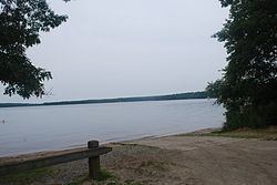
Watchaug pond is a kettle pond (lake) located at the southern tip of Rhode Island, in the town of Charlestown. It is surrounded by nature trails and is near the Audubon Society's Kimball Wildlife Refuge. The 573-acre (2.32 km2) pond is within 3,000 acres (12 km2) of public land. To access the public cement boat ramp at this pond, follow Prosser Trail to Sanctuary Road.
Map of Watchaug Pond, Charlestown, RI 02813, USA
References
Watchaug Pond Wikipedia(Text) CC BY-SA