
Topo map Morisset | Elevation 641 m | |
 | ||
Similar Lake Macquarie, Olney State Forest, Munmorah State Conserva, Mount Sugarloaf, Mount Ulandra | ||
Hunter lookout heaton state forest state forests of the watagan mountains
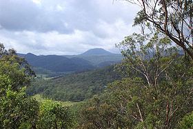
The Watagan Mountains or Watagans or Wattagan Mountains, a mountain range that is part of the Great Dividing Range, is located on the Upper Hunter region of New South Wales, Australia. The range is situated between the Upper Hunter River catchment and the Tuggerah Lakes. The Watagans are a popular tourist location and are close to Newcastle, Sydney and the Central Coast.
The highest point is Mount Warrawolong which rises to 641 metres (2,103 ft) above sea level.
The Watagans are covered with tall eucalyptus forest and rainforest. There are several camping areas and four wheel drive roads. Visitors should be careful as some areas can be quite steep and remote, with risky areas of near wilderness.
References
Watagan Mountains Wikipedia(Text) CC BY-SA