
Country United States Time zone Pacific (PST) (UTC-8) Zip code 99371 Local time Saturday 9:26 PM | Elevation 1,027 ft (313 m) Area code 509 Population 207 (2013) | |
 | ||
Weather 6°C, Wind W at 16 km/h, 64% Humidity | ||
Washtucna is a town in Adams County, Washington, United States. The population was 208 at the 2010 census, a 20% decrease over the previous census. The town was named for a lake 12 miles from the town in Franklin County which was in turn named after a Palouse Indian chief.
Contents
Map of Washtucna, WA 99371, USA
History
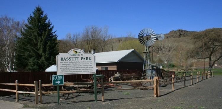
George Bassett, an Iowan settler homesteaded the future site of Washtucna in 1878 with his wife Alice Lancaster Bassett. Their goal was to raise horses, and until 1900 their ranch was the site of an annual roundup of wild horses. In 1882, the first Post Office in Adams County was established with Bassett as postmaster. The post office was taken over by T.C. Martin in 1894 who then opened the first store in Washtucna.
The first rail line into the area was completed by the Oregon Improvement Company in 1886, and shipped 30,000 bushels of wheat in its first five years. Several attempts at large-scale irrigation projects were attempted between 1892 and 1917, but all failed. Dry land wheat farming has persisted since that time.
Washtucna was officially incorporated on October 27, 1903, with Charles T. Booth as the first mayor.
Geography
Washtucna is located at 46°45'12" North, 118°18'46" West (46.753375, -118.312687).
Washtucna is located at the intersection of Washington Highways 26 and 261; about 65 miles West of Pullman, Washington, 86 miles Southwest of Spokane, Washington, and 220 miles East of Seattle, Washington
According to the United States Census Bureau, the town has a total area of 0.69 square miles (1.79 km2), all of it land.
2010 census
As of the census of 2010, there were 208 people, 97 households, and 62 families residing in the town. The population density was 301.4 inhabitants per square mile (116.4/km2). There were 126 housing units at an average density of 182.6 per square mile (70.5/km2). The racial makeup of the town was 95.2% White, 1.0% African American, 1.4% Native American, 1.4% from other races, and 1.0% from two or more races. Hispanic or Latino of any race were 2.4% of the population.
There were 97 households of which 18.6% had children under the age of 18 living with them, 47.4% were married couples living together, 11.3% had a female householder with no husband present, 5.2% had a male householder with no wife present, and 36.1% were non-families. 30.9% of all households were made up of individuals and 9.3% had someone living alone who was 65 years of age or older. The average household size was 2.14 and the average family size was 2.63.
The median age in the town was 51.6 years. 17.3% of residents were under the age of 18; 6.7% were between the ages of 18 and 24; 13.4% were from 25 to 44; 37.5% were from 45 to 64; and 25% were 65 years of age or older. The gender makeup of the town was 57.2% male and 42.8% female.
2000 census
As of the census of 2000, there were 260 people, 110 households, and 72 families residing in the town. The population density was 484.7 people per square mile (185.9/km2). There were 133 housing units at an average density of 247.9 per square mile (95.1/km2). The racial makeup of the town was 96.15% White, 1.92% Native American and 1.92% from two or more races. Hispanic or Latino of any race were 4.23% of the population.
There were 110 households out of which 32.7% had children under the age of 18 living with them, 50.0% were married couples living together, 11.8% had a female householder with no husband present, and 34.5% were non-families. 32.7% of all households were made up of individuals and 10.9% had someone living alone who was 65 years of age or older. The average household size was 2.36 and the average family size was 2.96.
In the town, the age distribution of the population shows 28.5% under the age of 18, 3.8% from 18 to 24, 23.8% from 25 to 44, 28.1% from 45 to 64, and 15.8% who were 65 years of age or older. The median age was 41 years. For every 100 females there were 89.8 males. For every 100 females age 18 and over, there were 91.8 males.
The median income for a household in the town was $34,688, and the median income for a family was $45,000. Males had a median income of $31,964 versus $33,750 for females. The per capita income for the town was $17,487. About 16.2% of families and 20.1% of the population were below the poverty line, including 29.8% of those under the age of eighteen and 8.9% of those sixty five or over.