
Existed: 1975 – present Length 24.43 km | South end: US 2 near Diamond Lake Counties: Pend Oreille Constructed 1975 | |
 | ||
County | ||
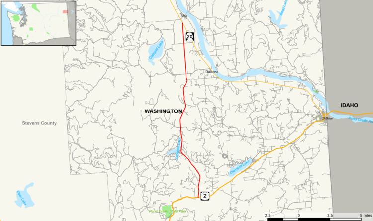
State Route 211 (SR 211) is a Washington state highway located in Pend Oreille County. The 15.18-mile (24.43 km) long route that begins at an intersection with U.S. Route 2 (US 2) east of Diamond Lake. The highway extends north to end at SR 20 in Usk, a small community south of Cusick. The roadway serves as a bypass of Newport. The route originally was established as Secondary State Highway 6B (SSH 6B) in 1937. SSH 6B was later renumbered to SR 311 in 1964 during the highway renumbering. After SR 20 was extended east over SR 31, the highway was renumbered to SR 211.
Contents
Map of WA-211, Washington, USA
Route description
State Route 211 (SR 211) begins its 15.18 miles (24.43 km) of highway at an intersection with U.S. Route 2 (US 2), a major west–east route, east of Diamond Lake. After the intersection, the road travels northwest to Sacheen Lake and north to Deer Valley before continuing northbound to Davis Lake. After Davis Lake, the road intersects Westside Kalispel Road and advances north to its terminus at SR 20 in Usk, located south of Cusick. North of the US 2 intersection, an estimated 2,200 motorists utilized Lewis Street daily based on average annual daily traffic (AADT) data collected by the Washington State Department of Transportation.
History
SR 211 was originally established as Secondary State Highway 6B (SSH 6B) in 1937, during the creation of the Primary and secondary highway system; the highway ran from U.S. Route 195 (US 195) to Primary State Highway 6 (PSH 6). US 195 later became US 2 in 1948, as part of a westward expansion. The Washington State Legislature renumbered and changed the system in 1964, PSH 6 became SR 31 and SSH 6B became SR 311. SR 20 was later extended east over the route of SR 31 in 1973 and SR 311 was renumbered to SR 211 in 1975.
Major intersections
The entire highway is in Pend Oreille County.