
Existed: 1964 – present Constructed 1964 | Length 98.64 km | |
 | ||
West end Makah Indian Reservation boundary near Neah Bay | ||
Washington state route 112 motorcycle ride
State Route 112 (SR 112, named the Strait of Juan de Fuca Highway) is a state highway extending 61.29 miles (98.64 km) within Clallam County in the U.S. state of Washington.
Contents
- Washington state route 112 motorcycle ride
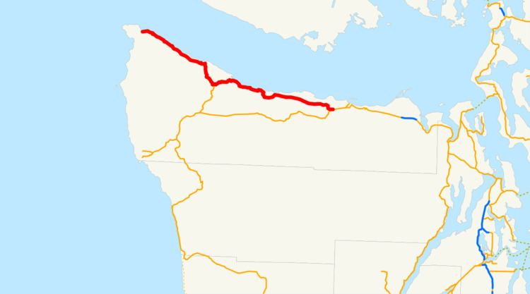
- Map of WA 112 Washington USA
- Route description
- History
- Major intersections
- References
Map of WA-112, Washington, USA
Route description
State Route 112 (SR 112) begins at the Makah Indian Reservation boundary east of Neah Bay and the delta of the Sail River. The Strait of Juan de Fuca Highway, a National Scenic Byway, also starts at the boundary and is concurrent with the whole highway. Traveling southeast along the Strait of Juan de Fuca and a cliff to Hoko, the roadway crosses the Hoko River before the river empties into the strait. After the bridge, the road starts to turn southeast away from the coast to Sekiu, where SR 112 passes the Sekiu Airport and travel on a cliff near Clallam Bay and passes the community of the same name. At Clallam Bay, the roadway turns south along the Clallam River inland to intersect the northern terminus of SR 113, which travels south to Sappho. The road curves northeast from the intersection along the Pysht River to Pysht, where another turn places the highway stays southeastward along the strait. Approaching Port Angeles, SR 112 travels through plains past Joyce and the Lower Elwha Indian Reservation, the highway crosses the Elwha River on a deck arch bridge. After the bridge, the roadway had an estimated daily average of 5,400 motorists in 2007. The road and scenic byway end at an intersection with U.S. Route 101 (US 101) west of Port Angeles.
History
When the primary and secondary highways were created in 1937, a branch of Primary State Highway 9 (PSH 9), named Secondary State Highway 9A (SSH 9A) was established and extended from PSH 9 in Sappho north and east to PSH 9 in Port Angeles. By 1953, a road extending from Neah Bay to SSH 9A was completed and in 1955, the roadway was added to SSH 9A, while the Sappho segment was deleted. During the 1964 highway renumbering, SSH 9A became SR 112; the highway became a state scenic byway in 1967. The Sappho segment of SSH 9A later was readded to the state highway system in 1991 as SR 113. On June 15, 2000, SR 112 became a National Scenic Byway named the Strait of Juan de Fuca Highway. A late December winter storm in 2008 resulted in floods that triggered a landslide that closed the highway near Joyce on January 8, 2009. Temporary repairs began on March 2 and only one-way traffic was allowed until the roadway reopened on March 12.
Major intersections
The entire highway is in Clallam County.