
Length 78.15 km | ||
 | ||
Counties | ||
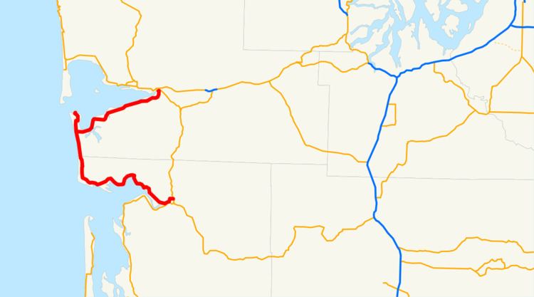
State Route 105 is a state highway in the U.S. state of Washington. It is 48.56 miles (78.15 km) long, and begins in Raymond, ending in Aberdeen, Washington. It connects to U.S. Route 101 at both ends. While US 101 is a coastal route for much of its length along the West Coast, between Raymond and Aberdeen it takes a more inland route, and SR 105 parallels Willapa Bay, the Pacific Ocean, and Grays Harbor.
Contents
Map of WA-105, Washington, USA
Route description
State Route 105 begins at an intersection with U.S. Route 101 in the northern part of Raymond, just north of US 101's intersection with State Route 6. It roughly follows the Willapa River then Willapa Bay westward, serving the towns of Tokeland and North Cove, then goes up the Pacific coast and back turns to the east just before Westport, where it meets with State Route 105 Spur. It then ends in south Aberdeen, near Cosmopolis, where it reconnects to U.S. Route 101.
Spur routes
State Route 105 Spur (more specifically referred to by the Washington State Department of Transportation (WSDOT) as "State Route 105 Spur Westport") is a spur of State Route 105 that goes north into the town of Westport, USA. It snakes through the city streets, initially as Forrest Street, finally ending at the harbor.
The SR 105/105 Spur junction is about 5 miles (8 km) north of Grayland, Washington, immediately adjacent to Twin Harbors State Park. The spur is 4.02 miles (6.47 km) long.
State Route 105 Spur can also refer to a 0.15-mile (240 m) section of the Aberdeen-area SR 105/U.S. Route 101 junction specifically referred to by WSDOT as "State Route 105 Spur Boone".
History
State Route 105 was added to Washington's state highway system in 1937 as Secondary State Highway 13-A. This definition also included the spur north to Westport. In the 1964 state highway renumbering, SSH 13-A was assigned the designation SR 105.
Between Grayland and Tokeland, SR 105 had to be re-routed inland from Cape Shoalwater, due to currents coming out of Willapa Bay causing severe erosion, taking many acres of land out to sea.