
Founded 1792 Unemployment rate 4.0% (Apr 2015) | Area 779.6 km² Population 11,875 (2013) | |
 | ||
Website www.washingtoncountyky.com Rivers Beech Fork, Chaplin River, Cartwright Creek, Pleasant Run | ||
Washington County is a county located in the U.S. state of Kentucky. As of the 2010 census, the population was 11,717. Its county seat is Springfield. The county is named for George Washington.
Contents
Map of Washington County, KY, USA
Washington County was the first county formed in the Commonwealth of Kentucky when it reached statehood, and the sixteenth county formed. The center of population of Kentucky is located in Washington County, in the city of Willisburg.
The county is dry, meaning that the sale of alcohol is prohibited, but it contains the "wet" city of Springfield, where retail alcohol sales are allowed. This classifies the jurisdiction as a moist county. Three wineries operate in the county and are licensed separately to sell to the public. Jacob Beam, founder of Jim Beam whiskey, sold his first barrel of whiskey in Washington County.
History
Washington County was established in 1792 from land given by Nelson County. It was the first county created by the Commonwealth of Kentucky after its separation from Virginia.
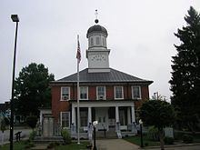
The Washington County Courthouse, completed in 1816, is the oldest courthouse still in use in Kentucky. A significant county court record is the marriage bond of Thomas Lincoln and Nancy Hanks, parents of President Abraham Lincoln. The bond is dated June 10, 1806; it was written the day before the marriage in the small community of Beechland on the Little Beech River. The marriage return was signed by Jesse Head, the Methodist preacher who performed the ceremony, and dates the marriage to June 12, 1806.
Geography
According to the U.S. Census Bureau, the county has a total area of 301 square miles (780 km2), of which 297 square miles (770 km2) is land and 3.9 square miles (10 km2) (1.3%) is water.
Adjacent counties
Demographics
As of the census of 2000, there were 10,916 people, 4,121 households, and 3,020 families residing in the county. The population density was 36 per square mile (14/km2). There were 4,542 housing units at an average density of 15 per square mile (5.8/km2). The racial makeup of the county was 90.62% White, 7.51% Black or African American, 0.16% Native American, 0.28% Asian, 0.61% from other races, and 0.82% from two or more races. 1.60% of the population were Hispanic or Latino of any race.
There were 4,121 households out of which 33.10% had children under the age of 18 living with them, 59.50% were married couples living together, 10.00% had a female householder with no husband present, and 26.70% were non-families. 24.00% of all households were made up of individuals and 11.40% had someone living alone who was 65 years of age or older. The average household size was 2.57 and the average family size was 3.03.
The age distribution was 25.30% under the age of 18, 8.80% from 18 to 24, 27.90% from 25 to 44, 23.10% from 45 to 64, and 15.00% who were 65 years of age or older. The median age was 37 years. For every 100 females there were 96.60 males. For every 100 females age 18 and over, there were 91.90 males.
The median income for a household in the county was $33,136, and the median income for a family was $39,240. Males had a median income of $27,624 versus $21,593 for females. The per capita income for the county was $15,722. About 10.30% of families and 13.50% of the population were below the poverty line, including 14.40% of those under age 18 and 19.60% of those age 65 or over.
Education
The county is served by Washington County Schools, a district that contains five schools:
St. Catharine College is located near Springfield.