
Population 741 (2011) Unitary authority Local time Saturday 9:07 PM | OS grid reference NY865775 Dialling code 01434 | |
 | ||
Weather 9°C, Wind SW at 3 km/h, 77% Humidity | ||
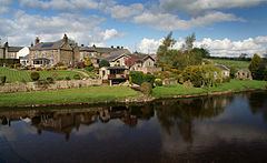
Wark on Tyne is a small village and civil parish usually called Wark in Northumberland, England about 12 miles (19 km) north of Hexham. The name is derived from the Viking word for Earthworks, and refers to the mound at the south of the village, where a meeting hall once stood. The hotel name 'battlesteads' is taken from the stables that once stood there, as the meeting hall was used as the main meeting place for the Clan Chieftains. Wark was also once the capital town of Tynedale, and still retains a Town Hall, rather than a Village Hall. A Bronze-age stone circle known as The Goatstones is located near Ravensheugh crags in Wark parish.
Contents
Map of Wark, Hexham, UK
Governance
Wark is in the parliamentary constituency of Hexham.
Transport
Wark was served by Wark railway station on the Border Counties Railway which linked the Newcastle and Carlisle Railway, near Hexham, with the Border Union Railway at Riccarton Junction. The first section of the route was opened between Hexham and Chollerford in 1858, the remainder opening in 1862. The line was closed to passengers by British Railways in 1956. Part of the line is now beneath the surface of Kielder Water. Wark Bridge crosses the River Tyne.