
Postcode(s) 2046 Wareemba Russell Lea Postal code 2046 Federal division Division of Reid | LGA(s) City of Canada Bay Area 30 ha State electorate(s) Drummoyne Population 1,390 (2006 census) | |
 | ||
Location 12 km (7 mi) from Sydney CBD | ||
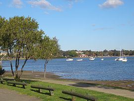
Wareemba is the smallest suburb by area in Sydney, located in its inner-west in the state of New South Wales, Australia. Wareemba is 12 kilometres west of the Sydney central business district in the local government area of the City of Canada Bay. Wareemba sits on the eastern shore of Hen and Chicken Bay, on the Parramatta River.
Contents
Map of Wareemba NSW 2046, Australia
History
European settlement of the area began in the 1830s, with land mainly used for farming. The suburb was originally part of neighbouring suburb Abbotsford until declared a separate suburb in 1993. The name Wareemba comes from an Aboriginal word meaning "place where sweet water meets salt water".
Commercial area
Wareemba has a small group of shops located on Great North Road. Wareemba is famous for its coffee shops, including one business that combines fruit shop with coffee shop.
Churches
Wareemba Gospel Hall is in Coranto Street.
Population
The suburb of Wareemba had a population of 1,390 people, according to the 2006 Census of Population and Housing.
Demographics
Like the nearby suburbs of Haberfield and Five Dock, Wareemba has a large population of residents with Italian ancestry. In the 2006 census, 16% of the population of Wareemba noted their country of birth as being Italy, the second most frequent response after Australia (65%).