
Highest point Walker Hill Elevation 415 m Population Uninhabited | Highest elevation 415 m (1,362 ft) Area 13.9 km² | |
 | ||
Archipelago Queen Elizabeth Islands | ||
Ward Hunt Island is a small, uninhabited island in the Arctic Ocean, off the north coast of Ellesmere Island. Its northern cape is one of the northernmost elements of land in Canada. Only a 17 km stretch of northern coast of Ellesmere Island around Cape Columbia is more northerly. The island is 6.5 km (4.0 mi) long, east to west, and 3.3 km (2.1 mi) wide. The first known sighting was in 1876 by Pelham Aldrich, a lieutenant with the George Nares expedition, and named for George Ward Hunt, First Lord of the Admiralty at the time (1874-1877).
Contents
Map of Ward Hunt Island, Baffin, Unorganized, NU, Canada
History
Ward Hunt Island was briefly used as a weather station during the International Geophysical Year of 1957-58, and since then it has been used as the starting point for a number of attempts to reach the North Pole, beginning with Ralph Plaisted in 1968. There is an airstrip and a building on the north shore.
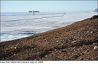
On July 29, 2008, a giant chunk of ice broke away from the shelf on Ward Hunt Island. The new ice island had an area of 35.9 km2 (13.9 sq mi). It was the largest fracture of its kind since the nearby Ayles Ice Shelf—which measured 66 km2 (25 sq mi)—broke away in 2005.
In 1959, an American geologist, Paul T. Walker, put a note in a bottle and built a cairn over it near a glacier 800 kilometres north of Grise Fiord, Nunavut. The note stated that the cairn was 1.2 metres in front of a glacier, and left instructions to measure the distance again when the note was found. Researchers from Laval University found it in the summer of 2013. The distance by then was 101.5 m. At the time, few scientists were expecting glaciers to retreat.
In July 2016, A team of scientists with the Canadian Armed Forces while conducting a site visit of Eureka Station, Tanqueray Fjord, and Ward Hunt Island found a cairn erected by PM P.E.Trudeau. A picture of the plaque was presented to PM. J. Trudeau by Defense Minister Harjit Sajjan on behalf of the Canadian Armed Forces.