
- elevation 7,940 ft (2,420 m) - elevation 6,234 ft (1,900 m) Cities Pine Land, Timberland | - location Tahoe Pines | |
 | ||
Similar Lake Tahoe, Burton Creek State Park, Burleigh H Murray Ranch, Caspar Headlands State Bea, John Little State Natural R | ||
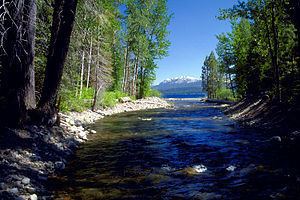
Ward Creek is a 6.1-mile (9.8 km) eastward-flowing stream in Placer County, California, USA. The creek flows into Lake Tahoe 2.7 miles (4.3 km) south of Tahoe City, California and has undergone extensive restoration to reduce sediment and surface run-off to maintain the purity of Lake Tahoe.
Contents
Map of Ward Creek, California, USA
HistoryEdit
Ward Creek and Ward Peak are named for homesteader Ward Rush, whose claim was made on April 1, 1874. In the early 1980s the McClatchy family donated lands on the south side of the creek to California State Parks.
WatershedEdit
Ward Creek, the fourth largest stream (by area and discharge)of the 63 Tahoe Basin watersheds contributes 6% of the stream runoff flowing into Lake Tahoe. The creek was a major source of sediment related to erosion from subdivisions and logging roads in the watershed. The Ward Creek watershed drains an area of 6,200 acres (2,500 ha) and has a North Fork beginning on the south slope of Ward Peak and a South Fork originating on the north side of Twin Peaks. The Ward Creek watershed is just north of the Blackwood Creek watershed, and just south of Alpine Meadows Ski Resort which is on the north side of Ward Peak and Scott Peak. The creek mainstem is paralleled by Ward Creek Boulevard/Road.
EcologyEdit
From 2006 to 2013 Ward Creek Park was restored by California State Parks, the California Tahoe Conservancy and other partners to reduce erosion which deposites sediment in Lake Tahoe, removal of fire-prone crowded trees and removal of a diversion dam.
Beaver dams on Ward Creek reduce sediment and nutrient (such as phosphorus) loads that would otherwise flow to Lake Tahoe. Recent evidence has shown that beaver (Castor canadensis) are native to the Sierra Nevada. Their dams do not appear to pose barriers to trout passage.
RecreationEdit
Ward Creek Park is a California State Park whose 180 acres is bordered by Ward Creek on the north and Highway 89 on the east. The area along the creek is protected by the California State Parks system. The Park has an extensive trail system that ties in with the bike path along Highway 89 and connects with USFS trails to Stanford Rock (which lies midway between Twin Peaks and the mouth of Ward Creek) and the Tahoe Rim Trail.