
Type Tiered Longest drop 300 ft (90 m) Number of drops 3 World height ranking 148 | Total height 1,080 ft (330 m) Height 329 m | |
 | ||
Similar Hetch Hetchy, Yosemite National Park, Tueeulala Falls, O'Shaughnessy Dam, Chilnualna Falls | ||
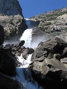
Wapama Falls is the larger of two waterfalls located on the northern wall of Hetch Hetchy Valley in Yosemite National Park. It flows almost year-round and during peak flow has been known to inundate the trail bridge crossing its base, making the falls impossible to pass. The falls consist of two primary drops angled roughly 60 degrees to each other, and a broad cascade at its base. Wapama Falls is fed by Lake Vernon, a few miles to the north.
Map of Wapama Falls, California, USA
Wapama Falls descends just under 1,100 feet. Like Yosemite Falls, it has three distinct parts. The topmost is a free drop of perhaps 300 feet, followed by a steeply-cascading stream which descends 600 feet in a steep-sided gorge, much like the stream between Upper and Lower Yosemite Fall. These cascades cannot be seen in their entirety from the trail: such a view is seen from across the Valley high on Kolana Rock. Finally, the bottom drop, seen from the dam and intimately from the trail, is one of about 200 feet down an escarpment that is not vertical, but in high water the water shoots outward to clear this descent.
Visitors can reach Wapama Falls by hiking 2.5 miles (4.0 km) up Hetch Hetchy Reservoir Trail from O'Shaughnessy Dam.