
District Wanaparthy Time zone IST (UTC+5:30) Area 27.34 km² | Elevation 402 m (1,319 ft) 509103 509 103 Local time Sunday 2:14 PM | |
 | ||
Weather 39°C, Wind SE at 8 km/h, 22% Humidity Neighborhoods Bhagathsinghnagar, R.T.C Colony, Teachers Colony, Vengal Rao Nagar Colony, Chandapur | ||
Wanaparthy is a municipal town in Wanaparthy district of Telangana, India. It covers an area of about 70.8 square kilometres (27.34 sq mi). The first polytechnic college in Telangana started in Wanaparthy.
Contents
Map of Wanaparthy, Telangana 509103
History
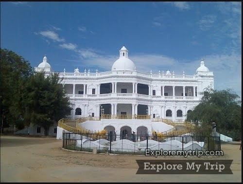
Wanaparthy was governed by a feudal ruler, Rameshwar Rao II, Raja of Wanaparthy, who was a vassal of the Nizam of Hyderabad. Wanaparthy was one of the 14 major Zamindari segments in Telangana in Post-Independent India. Raja died on November 22, 1922. As his successor, Krishna Dev was a minor, his estate was managed by the Court as his ward. Krishna Dev died before attaining adulthood and the crown passed on to his son Rameshwar Rao III. Soon after India abolished all regal titles. After the formation of the Telangana Government, Wanaparthy is proposed as a district along with other 14 new district proposals to the new government apart from the 10 existing districts.
Demographics
According to the 2011 Census of India, the town had a population of 60,949. The total population constituted 31,501 males, 29,448 females and 6,122 children (age group of 0–6 years). The average literacy rate was 77.91% with 42,713 literates, higher than the national average of 73.00%.
Wanaparthy Samsthanam
Wanaparthy Samsthanam or Raja of Wanaparthy was a vassal of Nizam of Hyderabad. He controlled the feudatory of Wanaparthy.