
Elevation 202 m Zip code 12588 Area code 845 | Area 5.4 km² Population 853 (2010) | |
 | ||
Real estate video tour 248 walker valley rd pine bush ny 12566
Walker Valley (70°41′S 67°33′E) is a large, wide, snow-filled valley lying immediately west of Manning Massif in the Aramis Range, Prince Charles Mountains. Mapped from ANARE (Australian National Antarctic Research Expeditions) air photographs. Named by Antarctic Names Committee of Australia (ANCA) for K.G. Walker, expedition assistant with the ANARE Prince Charles Mountains survey party in 1970.
Contents
- Real estate video tour 248 walker valley rd pine bush ny 12566
- Map of Walker Valley NY 12566 USA
- References
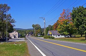
Map of Walker Valley, NY 12566, USA
References
Walker Valley Wikipedia(Text) CC BY-SA