
Country United States County Ellis Time zone Central (CST) (UTC-6) Elevation 592 m | State Kansas Founded 1872 ZIP code 67674 Local time Friday 11:21 AM | |
 | ||
Weather 15°C, Wind S at 43 km/h, 41% Humidity | ||
Walker is an unincorporated community in Herzog Township, Ellis County, Kansas, United States. Walker has a post office with ZIP code 67674.
Contents
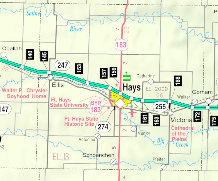
Map of Walker, KS 67640, USA
History
Settlers from Ohio founded Walker in 1872. They likely named the settlement for Robert J. Walker, the 4th Territorial Governor of Kansas. From 1876 to 1878, they were joined by Volga German immigrants and Plattdeutsch-speaking Germans from Ohio and Kentucky who settled in the area.
The first post office in Walker opened in 1873, closed temporarily in 1876, and then reopened in 1878. St. Ann's Church was built and dedicated in 1905. The community's first school was built in 1893, followed by a second building in 1925. The school has since closed but remains in use as a community center.
In 1942, the U.S. Army built Walker Army Airfield one mile northwest of Walker. During World War II, thousands were stationed at the airfield, mostly for training in operation of the Boeing B-29 Superfortress bomber aircraft. The military closed the base in 1946.
Construction of Interstate 70 reached Walker in 1966, passing immediately south of the community.
Geography
Walker is located at 38°52′02″N 99°04′33″W (38.8672339, -99.0759271) at an elevation of 1,942 feet (592 m). It lies approximately 1.5 miles (2.3 km) west of Walker Creek, part of the Smoky Hill River watershed, in the Smoky Hills region of the Great Plains. Walker is immediately north of Interstate 70 roughly 13 miles (21 km) east of Hays, the county seat.
Transportation
Walker Avenue, a paved county road, runs north-south through Walker, intersecting Interstate 70 and U.S. Route 40, which run concurrently east-west, immediately south of town. The old alignment of U.S. 40, now a paved county road, runs northeast-southwest through Walker.
The Kansas Pacific (KP) line of the Union Pacific Railroad runs northeast-southwest through Walker, parallel to the old alignment of U.S. 40.