
Basin size 3,050 km (1,180 sq mi) Basin area 3,050 km² Mouth Waikato River | Length 115 km Source Rangitoto Range Country New Zealand | |
 | ||
Tributaries Left:
Wharekiri Stream, Kaama Stream, Waiharakea Stream, Otanetapoto Stream, Mangawhaka Stream, Ngakuratro Stream, Mangawhero Stream, Mangapu River, Orahiri Stream, Waitomo Stream, Mangamahoe Stream, Owaikura Stream, Ongaruhe Stream, Moakurarua Stream, Ngakoaohia Stream, Mangauika Stream, Ngaparierua Stream, Mangawawe Stream, Mangamauku Stream, Mangao Stream, Waikoha Stream, Paratawa Stream, Tunaeke Stream, Karakariki Stream, Mangaotama Stream, Karangatuoro Stream, Timaru Stream, Te Paki Stream, Maroheno Stream, Firewood Creek, Mangarata Stream.
Right:
Otamaroa Stream, Okahukura Stream, Mata Stream, Tunawaea Stream, Owawenga Stream, Tauraroa Stream, Parapara Stream, Mohoanui Stream, Mangaoronga Stream, Okuri Stream, Okohau Stream, Mangawhero Stream, Puniu River, Mangapiko Stream, Mangakaware Stream, Mangaotama Stream, Mangahia Stream, Koromatua Stream, Ohote Stream. Discharge Average rate:
83.9 m/s (2,960 cu ft/s) River mouth Waikato River; 20 m (66 ft) Main source Rangitoto Range; 703 m (2,306 ft) | ||
The Waipa River is in the Waikato region of the North Island of New Zealand. The headwaters are in the Rangitoto Range east of Te Kuiti. It flows north for 115 kilometres (71 mi), passing through Otorohanga and Pirongia, before flowing into the Waikato River at Ngaruawahia. It is the Waikato's largest tributary. The Waipa's main tributary is the Puniu River.
Contents
- Map of Waipa River Waikato New Zealand
- Speed of flow
- Power stations
- Pollution
- Soil conservation
- Bridges
- Steamer services
- References
Map of Waipa River, Waikato, New Zealand
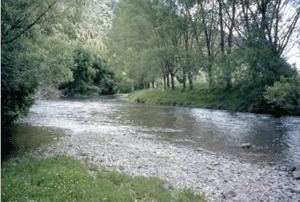
In the headwaters upstream of Otorohanga the river can be very clear during low flow conditions. This section of the river flows through rough farmland and patches of native bush. In this clearer part of the river there can be very good fly fishing for trout, but you'll need to ask the land owners permission to access the river.
The Waipa is prone to flooding in its lower reaches as flood flows can be over 100 times—20 to 560 m3/s (710 to 19,780 cu ft/s)—those of dry flows and the river can rise up to 11 m (36 ft).
Speed of flow
The table below shows the time water takes to flow the 130 km (81 mi) from Te Kuiti to its confluence with the Waikato in times of low flow (15% of days are slower than this) and high flow (15% of days faster) -
Power stations
In 2003 Hydro Power Ltd was given consent to build a hydro-electric power station, with weirs in the Okahukura Stream, upstream from Owen Falls, and penstocks carrying water down the gorge to a station on the west bank 2.5 kilometres (1.6 mi) below the falls. Work was done in 2006, but, in 2007, Hydro Energy (Waipa) Ltd was fined for unconsented damage to native vegetation in building the penstock. The resource was initially estimated to be able to generate 10 to 20MW. Construction halted, though Renewable Power bought the asset in 2010 and estimates potential at 9MW.
In 2016 Nova Energy applied for consent to build a 360MW gas-turbine station (connected to the Maui Gas Pipeline) on the Ongaruhe Stream, close to its confluence with the Waipa.
Pollution
Waikato Regional Council measures water quality monthly at five sites from Mangaokewa to Whatawhata. The measurements show poor quality along most of the river, with excess nitrogen, silt and phosphorus, though E. coli levels have improved with improved sewage treatment, though generally not enough for safe swimming; recreational rivers should have median E. coli levels below 126 per 100ml, but Waipa's range from 160 to 320. Turbidity levels north of Otorohanga rise to more than double the levels needed to support plant photosynthesis and phosphorus levels also rise above targets in that stretch. Nitrogen levels increased at all five sites between 1993 and 2012 due to intensified land use, now adding 3,075 tonnes a year. By comparison, the total from sewage works and Te Awamutu dairy factory is 66 tonnes.
Ministry for the Environment figures averaged between 1998 and 2007 showed the Waipa at Otorohanga had 280 E.coli per 100ml (53rd worst out of 154), 360 faecal coliforms per 100ml (83rd of 252), 0.55 mg/litre nitrogen (161th of 342) and 0.03 mg/litre phosphorus (187th of 361).
At Pirongia the figures were 390 E.coli per 100ml (35th worst out of 154), 425 faecal coliforms per 100ml (64th of 252), 0.49 mg/litre nitrogen (174th of 342) and 0.06 mg/litre phosphorus (80th of 361).
At Whatawhata the figures were 0.92 mg/litre nitrogen (94th of 342) and 0.06 mg/litre phosphorus (69th of 361).
In the Mangaokewa stream 0.02 mg/litre phosphorus (237th of 361).
Soil conservation
Regional Council estimates that 8,718 ha (21,540 acres) is at risk of severe erosion in the Middle Waipa (Waitomo, Turitea, Pirongia, Karakariki, Puniu, Mangaotama, Mangawhero and Mangapiko catchments) and 350 km (220 mi) of stream bank to be prone to erosion. Project Watershed plans for planting on 1,594 ha (3,940 acres), plus 976 km of stream bank and 1,332 km of fencing, from 2017 to 2026.
Bridges
Listed in order from the confluence with the Waikato and moving south they are:-
Steamer services
Over 50 kilometres (31 mi) was navigable by waka and Pirongia (Alexandra) was busy as the head of steamboat navigation until the railway was built to Te Awamutu in 1880, though some settlers used it as far as Te Kuiti. However, a 1915 guidebook still said, "Small steamers ply up and down the river from Huntly". An 1881 article said a journey upriver would normally take 36 hours, but more in dry weather, when shoals at Whatawhata and Te Rore were hard to cross. Around 1900 the Freetrader, owned by the Waikato Company, "was withdrawn owing to competition from the Walsh brothers with their launch Victory, which could traverse the winding Waipa much more easily than the cumbersome stern-wheeler." As late as 1919 Waipa County Council pressed for removal of shingle shoals to permit navigation to Pirongia and got money for improvements from government and the county councils. Evidence given to the Inland Waterways Commission in 1921 said boats carrying 20 tons could reach Pirongia for most of the year and, up to about 30 years before, vessels carried 60 tons to Pirongia and a special fleet of steamers ran to Te Kuiti.