
Country United States Elevation 13 ft (4 m) FIPS code 15-74000 Population 3,860 (2010) | Area code(s) 808 Zip code 96791 Local time Thursday 10:40 AM | |
 | ||
Time zone Hawaii-Aleutian (UTC-10) Weather 28°C, Wind NE at 16 km/h, 59% Humidity Points of interest Mokulē‘ia Beach, Waialua District Park, Small Planet Studios | ||
Waialua is a census-designated place and North Shore community in the Waialua District on the island of Oʻahu, City & County of Honolulu, Hawaii, United States. As of the 2010 Census, the CDP had a population of 3,860.
Contents
Map of Waialua, HI 96791, USA
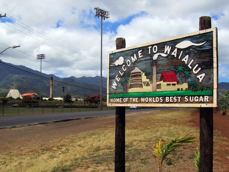
Waialua was one of the six original districts of ancient Hawaii on the island, known as moku. Waialua is a former (sugar) mill town and residential area, quite different in its quiet ambiance from nearby Haleʻiwa, which is more commercial and tourist oriented. The Waialua Sugar Mill is the center of this town and the historical base of its plantation history.
The U.S. postal code for Waialua is 96791.
Geography
Waialua is located at 21°34'31" North, 158°7'46" West (21.575300, -158.129457), southwest of Haleʻiwa, reached on Waialua Beach Road (State Rte. 82) or Kaukonahua Road (State Rte. 830). Kaukonahua Road turns eastward and, as State Rte. 803 then 801 runs up into the central plateau of Oʻahu to Wahiawā or (as 803) to Schofield Barracks. Farrington Highway (State Rte. 930) runs westward to Mokulēʻia.
According to the United States Census Bureau, the CDP has a total area of 2.4 square miles (6.2 km2), of which 2.2 square miles (5.7 km2) is land and 0.19 square miles (0.5 km2) is water. The total area is 8.30% water.
Demographics
As of the census of 2000, there were 3,761 people, 1,128 households, and 882 families residing in the CDP. The population density was 3,007.6 people per square mile (1,161.7/km²). There were 1,219 housing units at an average density of 974.8 per square mile (376.5/km²). The racial makeup of the CDP was 15.34% White, 0.37% Black or African American, 0.05% Native American, 51.85% Asian, 3.96% Pacific Islander, 1.04% from other races, and 27.39% from two or more races. 6.54% of the population were Hispanic or Latino of any race.
There were 1,128 households out of which 29.3% had children under the age of 18 living with them, 55.4% were married couples living together, 14.5% had a female householder with no husband present, and 21.8% were non-families. 17.5% of all households were made up of individuals and 8.3% had someone living alone who was 65 years of age or older. The average household size was 3.31 and the average family size was 3.71.
In the CDP the population is spread out with 23.9% under the age of 18, 7.7% from 18 to 24, 26.4% from 25 to 44, 23.1% from 45 to 64, and 18.9% who are 65 years of age or older. The median age is 39 years. For every 100 females there are 104.3 males. For every 100 females age 18 and over, there are 101.3 males.
The median income for a household in the CDP is $46,763, and the median income for a family is $51,801. Males have a median income of $29,607 versus $23,716 for females. The per capita income for the CDP is $17,220. 11.7% of the population and 8.9% of families are below the poverty line. Out of the total population, 15.0% of those under the age of 18 and 9.0% of those 65 and older are living below the poverty line.
Education
Hawaii Department of Education operates public schools. Waialua Elementary School and Waialua High & Intermediate School are in the CDP.
Hawaii State Public Library System operates the Waialua Library.
History
Many of the current families living in Waialua are the results of agricultural industry which began in the early 20th century. There was an increased demand for workers as the industry grew, resulting in workers being brought in from China, Portugal, Japan, Korea, Puerto Rico, the Philippines and other areas. Upon arriving in Hawaii, many of these workers were assigned to work in the sugarcane plantations in Waialua. During the late 1980s and into the 1990s, the sugar production decreased as increasing labor and production costs caused producers to move overseas. Many of the families brought to Waialua during the sugar rush remained here and many of their descendants reside there today.