
Basin countries Canada | River sources Sila River Settlements Uninhabited | |
 | ||
Wager Bay (previously: Wager River) is long narrow inlet in Kivalliq Region, Nunavut, Canada which opens east into Roes Welcome Sound at the northwest end of Hudson Bay. Ukkusiksalik National Park surrounds it.
Contents
Map of Wager Bay, Keewatin, Unorganized, NU, Canada
Wager Bay was first charted by Christopher Middleton during his Arctic explorations of 1742. He named it after Sir Charles Wager and was trapped in the bay for three weeks until the ice cleared in Roes Welcome Sound. In 1747 William Moor sent boat parties to the head of the bay.
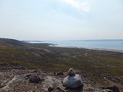
Geography
The bay is a long inlet stretching through tundra; its shoreline measures 93 mi (150 km) in length. The elevation is 51 m (167 ft) above sea level. It drains an area of 28,551 km2, through numerous small rivers, including the Brown River and Sila River. North Lake, South Lake, Brown Lake, and Ford Lake are nearby.