
District Ōshima -Flower Teppōyuri Population 6,929 (1 Jun 2013) | - Tree Banyan Area 40.37 km² Local time Friday 3:22 AM | |
 | ||
Weather 21°C, Wind S at 26 km/h, 87% Humidity | ||
Wadomari (和泊町, Wadomari-chō) is a town located on Okinoerabujima, in Ōshima District, Kagoshima Prefecture, Japan.
Contents
- Map of Wadomari Oshima District Kagoshima Prefecture Japan
- Geography
- Climate
- Surrounding municipalities
- History
- Economy
- Transportation
- References
Map of Wadomari, Oshima District, Kagoshima Prefecture, Japan
As of June 2013, the town has an estimated population of 6,929 and a population density of 172 persons per km². The total area is 40.37 km².
Geography
Wdamori is located on the northern end of Okinoerabujima.
Climate
The climate is classified as humid subtropical (Köppen climate classification Cfa) with very warm summers and mild winters. Precipitation is high throughout the year, but is highest in the months of May, June and September. The area is subject to frequent typhoons.
Surrounding municipalities
History
Wadamori Village was founded on 1 April 1908. It was upgraded to town status on 1 May 1941. As with all of Okinoerabujima, the town came under the administration of the United States from 1 July 1946 to 25 December 1953.
Economy
Sugar cane, sweet potato, and peanut farming are popular. Floriculture is also practiced. However, due to the lack of local jobs, there has been an outflow of residents.
Transportation
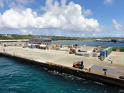
Wadomari Port is the main ferry port on the island, with connections to the prefectural capital Kagoshima. It takes between 17 and 18 hours. Okinoerabu Airport, is located in Wadomari. Wadomari is located on Kagoshima Prefectural Route 84.