
Time zone CET/CEST (UTC+1/+2) Population 1,569 (31 Dec 2008) | Elevation 405 m (1,329 ft) Local time Thursday 8:30 PM Postal code 99885 | |
 | ||
Municipal assoc. Ohrdruf (fulfilling community) Weather 7°C, Wind NW at 14 km/h, 58% Humidity | ||
Wölfis is a municipality in the district of Gotha, in Thuringia, Germany. Its administrative community is Ohrdruf.
Contents
Map of 99885 W%C3%B6lfis, Germany
Geography
The village lies in the valley of the stream Schill (formerly Reed Bach) that joins at the northwestern edge of the village with the stream Hopbach (formerly Rotenbach) and forms the border with a military training area in the north. From there, it flows to north of Ohrdruf to the river Ohra. The biggest part of its territory is occupied by the military training area, immediately adjacent to the northern outskirts of the village. In the south of the village lies the northern edge of the Thuringian Forest. The road L 2148 passes through the community, northwest to Ohrdruf, and south to Crawinkel.
History
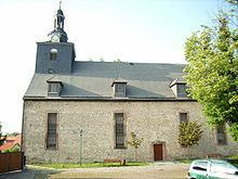
At the beginning of the 9th Century, the location is mentioned as Wolfduze in a directory of the Patrimony of Lullus, Archbishop of Mainz. On 20 January 1735 a fire left over 199 buildings in ruins, including the church parsonage, and both school buildings. Church records were destroyed by fire, creating a scarcity of information on the early history of the village. Using donations, a new church was built, and consecrated on 16 October 1736. By 1780, the village had largely recovered and counted 294 homes, and had 1100 inhabitants.
Population
(From 1994 on 31. Dezember): Data Source: Thuringian State Office for StatisticsCulture
There has been a tradition of brass music in the village since 1878. Today, there are two town orchestras, the Children and Youth Concert Band (Kinder und Jugendblasorchester), as well as Concert Wölfis (Blasorchester Wölfis). Both orchestras have 40 members, and are actively appearing at events in Thuringia and other states.