
Elevation 5 m (16 ft) Postal code 166 73 | Municipality Vari-Voula-Vouliagmeni Time zone EET (UTC+2) Local time Wednesday 8:07 AM | |
 | ||
Weather 15°C, Wind N at 2 km/h, 66% Humidity | ||
Voula (Greek: Βούλα) is a town and former municipality in East Attica, Greece. Since the 2011 local government reform it is part of the municipality Vari-Voula-Vouliagmeni, of which it is the seat and a municipal unit. The municipal unit has an area of 8.787 km2. Grigoris Kasidokostas is the mayor, elected at 14 November 2010 for the new municipality Vari-Voula-Vouliagmeni.
Contents
Map of Voula, Greece
Geography
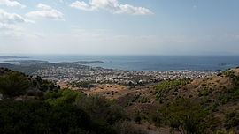
Voula is a southern suburb of Athens, 16 km south of the city centre. It is located on the Saronic Gulf coast, at the southwestern foot of the Hymettus mountain. Adjacent coast towns are Glyfada to the northwest and Vouliagmeni to the south. The Greek National Road 91 (Athens - Sounio) passes through Voula. One of the largest hospitals in the Athens conurbation, "Asklipieio", lies in the northern part of Voula. It is served by the southern terminus of the Athens Tram lines 3 and 5, Asklipieio Voulas.
Sports
Voula hosts the basketball club Proteas Voulas, founded in 1980.