
Time zone (UTC+4) Local time Wednesday 8:15 AM | Elevation 850 m (2,790 ft) Area 11.57 km² Population 818 (2011) | |
 | ||
Weather 7°C, Wind W at 3 km/h, 65% Humidity | ||
Voskepar (Armenian: Ոսկեպար; formerly, Aksibara and Akhsibara) is a village in the northeastern Tavush Province of Armenia, 163 kilometres (101 mi) north of Yerevan. It neighbors Yuxarı Əskipara village (Verin Voskepar in Armenian), an Armenian-controlled Azerbaijani exclave, as well as the other Azeri exclave of Aşağı Əskipara (Lower Askipara) village.
Contents
- Map of Voskepar Armenia
- Etymology
- History
- Nagorno Karabakh War
- Geography
- Demographics
- Economy
- Attractions
- Education and community facilities
- References
Map of Voskepar, Armenia
Etymology
Voskepar derives its name from the Voskepar mountain range; from the Armenian Ոսկե (voske, gold) plus պարան (paran: string or chain).
History
Voskepar was founded in the 6th century.
Nagorno-Karabakh War
In the Nagorno-Karabakh War 7 persons were killed in inter-ethnic fighting.
In 1991, the second operation of Operation Ring took place in and around Voskepar. This was a military operation conducted by Soviet Internal Security Forces and OMON units, officially dubbed a "passport checking operation," the stated goal launched by the Soviet Union's internal and defense ministries was to disarm Armenian militia detachments, which were organized in "[illegally] armed formations." The operation involved the use of soldiers who accompanied a complement of military vehicles, artillery and helicopter gunships to be used to root out the self-described Armenian fedayeen. However, contrary to their stated objectives, Soviet troops and the predominantly Azerbaijani soldiers in the Azerbaijan SSR OMON and army forcibly depopulated many Armenians. Some authors have also described the actions of the joint Soviet and Azerbaijani force as ethnic cleansing. According to Svante E. Cornell, Operation ring was carried out with 'harshly systematic Human Rights violations'.
Five Azerbaijani soldiers were killed in a conflict near the de facto border in May 2012.
Geography
The town lies in a valley to the south of the Voskepar Ridge, which reaches heights of 1,538 metres (5,046 ft). The average temperature is 30 °C (86 °F) in summer and −2 °C (28 °F) in winter.
Demographics
The population on January 1, 2012, was de facto 869. On January 1, 2008, the de jure population was 880. The population at the 2001 census was de facto 883, of which 429 male and 454 female; de jure 956 of which 478 male and 478 female.
Economy
The economy revolves around farming and cattle.
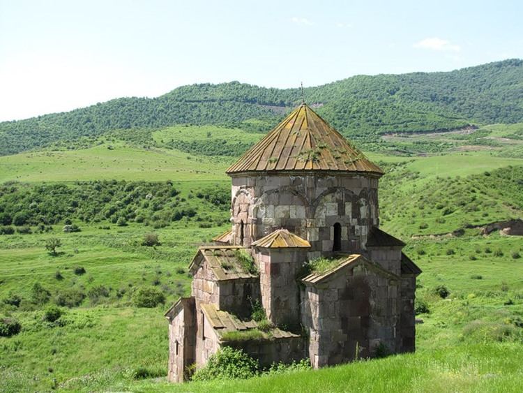
Attractions
The ancient Armenian church of the Holy Mother of God of Voskepar dates back to the 7th century.
Education and community facilities
There were 103 school pupils in 2011 and there was a health clinic, a house of culture, and community center. In addition to the St. Astvatsatsin Church (disused), there is St. Sarkin Church (2000).