
Municipal code 390 Area 621 km² | Time zone CET (UTC+1) Website www.vordingborg.dk Capital Vordingborg | |
 | ||
Points of interest Vordingborg Castle, GeoCenter Møns Klint, Ulvshale, Langø, Møns Klint Destinations | ||
Vordingborg is a municipality formed in 2007 (Danish, kommune) in Region Sjælland on the southeast coast of the island of Zealand (Sjælland) in south Denmark. The municipality includes the island of Masnedø, and covers an area of 621 km². It has a total population of 46,600 (2006). Its second and current mayor Knud Larsen, a member of the agrarian-liberal Venstre was elected in 2013, replacing Henrik Holmer of the Social Democrats.
Contents
Map of Vordingborg Municipality, Denmark
It is named after the town of Vordingborg.
Overview
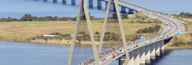
The Masnedsund Bridge connects the town of Vordingborg to the island of Masnedø. The Storstrøm Bridge connects Masnedø to neighboring municipality Guldborgsund on Falster near the town of Orehoved. The bridge is 3,199 meters long, and supports two lanes of traffic, plus a single track of railroad. It was inaugurated in 1937.
The Farø Bridges (The Farø High Bridge and the Farø Low Bridge) opened in 1985, and connect the two municipalities from the town of Bakkebølle Strand over Farø island (part of former Møn municipality) to Falster near the town of Sortsøgab. The island Bogø is also part of the municipality.
On January 1, 2007 Vordingborg municipality was merged with the neighboring municipalities Langebæk, Møn, and Præstø to form the enlarged Vordingborg Municipality as the result of Kommunalreformen ("The Municipal Reform" of 2007).
Directly east of Vordingborg Municipality around 135 km (84 mi) across the Baltic Sea is Bornholm, formed in 2003, the easternmost municipality of Denmark, which is a part of The Capital Region of Denmark.
For the location of the municipality compared to neighbors, see location map in corresponding article, at the bottom, on Danish language Wikipedia, Vordingborg Kommune.
Urban areas
The ten largest urban areas in the municipality are: