
 | ||
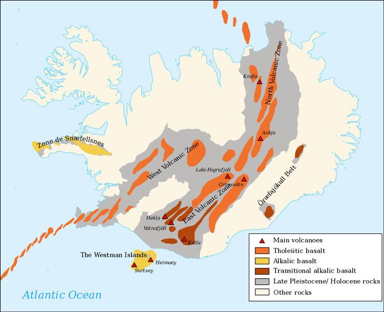
Iceland has a high concentration of active volcanoes due to its location on the mid-Atlantic Ridge, a divergent tectonic plate boundary, and also due to its location over a hot spot. The island has 30 active volcanic systems, of which 13 have erupted since the settlement of Iceland in AD 874.
Contents
Of these 30 active volcanic systems, the most active/volatile is Grímsvötn. Over the past 500 years, Iceland's volcanoes have erupted a third of the total global lava output.
The most fatal volcanic eruption of Iceland's history was the so-called Skaftáreldar (fires of Skaftá) in 1783-84. The eruption was in the crater row Lakagígar(craters of Laki) southwest of Vatnajökull glacier. The craters are a part of a larger volcanic system with the subglacial Grímsvötn as a central volcano. Roughly a quarter of the Icelandic nation died because of the eruption. Most died not because of the lava flow or other direct effects of the eruption, but from indirect effects, including changes in climate and illnesses in livestock in the following years caused by the ash and poisonous gases from the eruption. The 1783 eruption in Lakagígar is thought to have erupted the largest quantity of lava from a single eruption in historic times.
The eruption under Eyjafjallajökull ("glacier of Eyjafjöll") in 2010 was notable because the volcanic ash plume disrupted air travel in northern Europe for several weeks; however this volcano is minor in Icelandic terms. In the past, eruptions of Eyjafjallajökull have been followed by eruption of the larger volcano Katla, but after the 2010 eruption no signs of an imminent eruption of Katla were seen.
The eruption in May 2011 at Grímsvötn under the Vatnajökull glacier sent thousands of tonnes of ash into the sky in a few days, raising concerns of a repeat of the travel chaos seen across northern Europe.
Bárðarbunga 2014–2015
The eruption series that started on August 17, 2014, under the Bárðarbunga system started with an extremely heavy earthquake swarm followed by clusters of volcanic activity that went on for an extended period. This resulted in multiple lava fountain eruptions in Holuhraun. Lava flow was between 250 and 350 cubic meters per second and came from a dyke over 40 km long. There was very limited ash output from this eruption unlike numerous glacial eruptions which are common in Iceland. The primary concern with this eruption was the large plumes of sulphur dioxide (SO2) in the atmosphere which adversely affected breathing conditions across Iceland, depending on wind direction.
Structure of lava fields
The smooth flowing basaltic lava pāhoehoe is in Iceland called helluhraun. It forms rather flat surfaces that are quite easy to pass.
On the other hand, there is less flowing lava, ʻaʻā, on Iceland called apalhraun. The loose, broken, sharp, spiny surface of an ʻaʻā flow makes hiking difficult and slow.