Girish Mahajan (Editor)

Volcanic Eifel

Updated on
Edit
Like
Comment
Share on FacebookTweet on TwitterShare on LinkedInShare on Reddit
Volcanic Eifel httpswwwvilla1deuploadsimageskarte220300

Similar
  
Laacher See, Eifel, Schalkenmehrener Maar, Maria Laach Abbey, Ahr

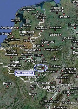
The Volcanic Eifel or Vulkan Eifel (German: Vulkaneifel) is a region in the Eifel Mountains in Germany, that is defined to a large extent by its volcanic geological history. Characteristic of this volcanic field are its typical explosion crater lakes or maars, and numerous other signs of volcanic activity such as volcanic tuffs, lava streams and volcanic craters like the Laacher See. The Volcanic Eifel is still volcanically active today. One sign of this activity is the escaping gases, for example, in the Laacher See.

Contents

Map of Volcanic Eifel, 56769 Mannebach, Germany

Geographical locationEdit

The Volcanic Eifel stretches from the Rhine to the Wittlich Depression. It is bordered in the south and southwest by the South Eifel, in the west by the Luxembourg and Belgian Ardennes and in the north by the North Eifel including the Hohes Venn. To the east the Rhine forms its geographical boundary; with no volcanicity immediately beyond it.

The Volcanic Eifel is divided into three natural regions:

  • Volcanic West Eifel (Manderscheid, Daun, Gerolstein, Obere Kyll, Hillesheim (within the parish of Nohn),
  • Volcanic High Eifel (Adenau, Kelberg, Ulmen and Nohn),
  • Volcanic East Eifel (Brohltal, Vordereifel, Mendig, Pellenz)
  • The centre of the Volcanic Eifel is the region around Daun and Manderscheid and the areas within the Mayen-Koblenz district.

    The landscape of the Volcanic Eifel is dominated by recent volcanism. Volcanic craters, thick pumice and basalt layers and maars create a diverse landscape, that clearly witnesses to very recent events in geological terms.

    The entire Volcanic Eifel covers an area of about 2000 km² and as of 2007 has a population of about 200,000.

    VolcanoesEdit

    The following volcanoes belong to the Eifel, sorted by height in metres (m) above sea level (Normalhöhennull, NHN):

  • Ernstberg (also: Erresberg; 699.8 m), county of Vulkaneifel – west
  • Scharteberg (691.4 m), county of Vulkaneifel; with the Eifel Transmitter (SWR) – west
  • Prümscheid (681 m), county of Vulkaneifel – not volcanic (eponymous quartzite ridge; other summits being the Scharteberg and Dietzenley)
  • Hochkelberg (674.9 m), county of Vulkaneifel; with a transmission mast on its south summit – Tertiary
  • Nerother Kopf (651.7 m), county of Vulkaneifel; with the castle ruins of the Freudenkoppe – west
  • Dietzenley (617.6 m), county of Vulkaneifel; with a wooden observation tower – west
  • Arensberg (ca. 590 m), county of Vulkaneifel – Tertiary
  • Hochsimmer (587.9 m), county of Mayen-Koblenz – east
  • Gänsehals (575.3 m), county of Mayen-Koblenz – east
  • Engelner Kopf (575.1 m), county of Ahrweiler (near Kempenich-Engeln) – east
  • Hochstein (563 m), county of Mayen-Koblenz – east
  • Steineberger Ley (557.8 m), county of Vulkaneifel; with a Volcano Information Platform (observation tower) – Tertiary
  • Rockeskyller Kopf (554.6 m), county of Vulkaneifel – west
  • Hoher List (549.1 m), county of Vulkaneifel; with the Hoher List Observatory – west
  • Wartgesberg (ca. 475 m), county of Vulkaneifel (near Strohn) – west
  • Veitskopf (428.1 m), county of Ahrweiler; near Laacher See; with an observation tower, the Lydia Tower – east
  • Ettringer Bellberg (427.5 m), county of Mayen-Koblenz (south of Ettringen) – east
  • Karmelenberg (372.5 m), county of Mayen-Koblenz – east
  • Mayener Bellberg (363.2 m), county of Mayen-Koblenz (north of Mayen) – east
  • Korretsberg (295.0 m), county of Mayen-Koblenz (near Kruft) – east
  • See also: List of mountains and hills of the Eifel

    Geopark and museumsEdit

  • Vulkanland Eifel National Geopark
  • Volcano Museum, Daun
  • Volcano House, Strohn
  • German Volcano Museum, Mendig
  • References

    Volcanic Eifel Wikipedia


    Similar Topics