
 | ||
A Volcanic Ash Advisory Center (VAAC) is a group of experts responsible for coordinating and disseminating information on atmospheric volcanic ash clouds that may endanger aviation. As at 2010, there are nine Volcanic Ash Advisory Centers located around the world, each one focusing on a particular geographical region. Their analyses are made public in the form of Volcanic Ash Advisories (VAA) and often incorporate the results of computer simulation models called Volcanic Ash Transport and Dispersion (VATD).
Contents
The worldwide network of Volcanic Ash Advisory Centers was set up by the International Civil Aviation Organisation (ICAO), an agency of the United Nations, as part of the International Airways Volcano Watch (IAVW), an international monitoring system managed by the International Airways Volcano Watch Operations Group (IAVWOPSG) which replaced the Volcanic Ash Warnings Study Group (VAWSG). The individual VAACs are run as part of national weather forecasting organisations of the country where they are based, e.g. the US NOAA or the British Met Office.
Precedents
The centers were set up in the 1990s to improve forecasts of the locations of ash clouds from volcanic eruptions following incidents where commercial aircraft had flown through volcanic ash resulting in the loss of engine power. British Airways Flight 9, a Boeing 747, lost power to all four engines in 1982 over Indonesia after an eruption of Mount Galunggung. KLM Flight 867, another Boeing 747, again lost power to all engines in 1989 over Alaska after Mount Redoubt erupted. It was recognised following these and other incidents that volcanic ash was a danger to commercial aviation and that the only way to ensure that there would be no loss of an aircraft was to alert pilots in a timely manner to divert their flight around the cloud.
Locations
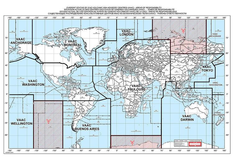
There are nine VAAC locations each with a defined area to monitor. The centers coordinate with adjacent VAAC, flight control centers within and adjacent to their area as well as meteorological offices within and adjacent to their area of operation.
The areas covered by the VAAC are set either by coordinates or by Flight Information Regions (FIR) that are internationally agreed as part of the IAVW program of the ICAO and the areas that each has responsibility is set out in the IAVW handbook.
The areas of responsibility for VAAC cover most of the world, with the exception of part of northern Russia and the Arctic; part of the South Pacific and the Antarctic, the areas that are not covered are shown by the hatched areas on the map.
Alerts
When an ash cloud is detected the VAAC will gather all the available information on this and then make use their computer models to predict the path of the ash cloud at different flight levels used by aircraft. They will then issue an alert to aviation and meteorological offices as stated within the IAVW procedure manual. This alert will be in the format of an alert stating that it is a Volcanic Ash Advisory.
Within the alert the following information will be provided: the name of the volcano, the country, location and crater elevation of the volcano, the source of the information, e.g. satellite or pilot observation, details of the eruption including time of day in UTC and date of the eruption, details of the ash cloud including the flight level and size, detail on the current movement of the ash cloud, forecast movement for 6, 12 and 18 hours ahead following the time of the advisory and finally the next update time.