
Existed: 1933 – present Constructed 1933 | Length 88.8 km | |
 | ||
Counties Richmond, Henrico County, Virginia, Charles City County, Virginia, James City County, Virginia, Williamsburg | ||
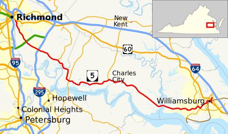
State Route 5 (SR 5) runs between the independent cities of Richmond and Williamsburg in the U.S. state of Virginia. Between Charles City County and James City County, it crosses the Chickahominy River via the Judith Stewart Dresser Bridge, a fixed-span bridge which replaced historic Barrett's Ferry and the former drawbridge.
Contents
Map of VA-5, Virginia, USA
The entire length of SR 5 outside Richmond and Williamsburg is a Virginia Byway.
Route description
For much of its distance, SR 5 generally parallels the north bank of the James River. It passes through three of the original 8 shires created in the Colony of Virginia in 1634 by King Charles I of England. These are Henrico County, Charles City County, and James City County.
James River plantations
Some of the larger and older of the extant James River Plantations are along the route. All are non-government-owned, and houses and/or grounds are generally open daily to visitors with various admission fees applicable. From west to east, these are the Shirley Plantation, Edgewood Plantation, Berkeley Plantation, Westover Plantation, Evelynton Plantation, Belle Air Plantation, Piney Grove at Southall's Plantation, North Bend Plantation and Sherwood Forest Plantation.
History
The first piece of SR 5 was added to the state highway system in 1923, running west from Charles City for 18.5 miles (29.8 km) towards Richmond, and was numbered State Route 41. Three more miles (5 km) were added in 1924, 6.39 miles (10.28 km) were added in 1925, and the remaining 3.5 miles (5.6 km), taking it to the Richmond city limits, were added in 1927.
An extension to the east, heading north from Charles City to State Route 39 (now U.S. Route 60) at Providence Forge, was added in 1926. However, this became State Route 413 in the 1928 renumbering, since a new alignment of SR 41, heading east from Charles City towards Williamsburg for eight miles (13 km), was added to the state highway system, as was a 4.5-mile (7.2 km) piece at the other end, heading west from State Route 510 (now State Route 31). A further 3.50 miles (5.63 km) from the west and 2.80 miles (4.51 km) from the east were added in 1930 and 1931, and, in 1932, the route was completed from Richmond to Williamsburg, with 3.00 miles (4.83 km) from the west and 1.70 miles (2.74 km) from the east.
The road from State Route 32 (now U.S. Route 15) at Zion Crossroads east to Oilville was added to the state highway system by 1923 as State Route 321. Extensiens east from Oilville were added for four miles (6 km) in 1924, six miles (10 km) in 1925, and 7.5 miles (12.1 km) in 1926. By 1927, SR 321 became an extension of SR 41 west from Richmond, and that year the former SR 321 was extended 3.5 miles (5.6 km), the rest of the way to Richmond.
SR 321/SR 41 was also extended west for 2.0 miles (3.2 km) in 1926, two more miles in 1927, and 5.4 miles (8.7 km) - the rest of the way to State Route 39 (now State Route 22) at Shadwell - in 1928.
In Richmond, SR 41 initially used Broad Street, a hairpin turn through Chimborazo Park, Fulton Street, Williamsburg Road, Hatcher Street, Newton Road, and New Osborne Turnpike.
State Route 39 from Shadwell west to Monterey, now U.S. Route 250, was part of the initial 1918 state highway system (numbered State Route 9 until 1923). It initially continued west from Monterey on present US 250, but by 1924 it used current State Route 84 west to West Virginia. The road west from Monterey towards West Virginia Route 56 (now U.S. Route 250) for 7.86 miles (12.65 km) was added to the state highway system in 1930 and 1932 as State Route 835; the remaining mileage to the state line was added in 1933.
In the 1933 renumbering, State Routes 41 and 835 both became part of a new State Route 5, as did the piece of State Route 39 from Monterey to Shadwell. By 1935, the whole route west of Richmond became an extension of U.S. Route 250 into Virginia, truncating SR 5 to its present Richmond-Williamsburg route.
SR 5 was extended east along State Route 31 through Williamsburg to State Route 168 (now State Route 143) "to improve the service to travelers interchanging between Route 5 and Routes 60 and 168" in 1958. SR 31 has since been truncated to the SR 5 junction.