
North end: SR 7 near Sterling North end SR 7 near Sterling | Length 78.9 km | |
 | ||
Existed: Former alignments: 1918–1933 (various parts from Lovingston to New Baltimore, replaced by US 29), 1926–1940 (New Baltimore to Centreville via Manassas), 1936–1966 (Herndon to Dranesville); current alignment: 1940 (Remington to Manassas), 1961 (Manassas to Chantilly), 1966 (Chantilly to VA 7) – present South end: US 15 / US 29 / SR 657 near Remington Counties Fauquier County, Virginia | ||
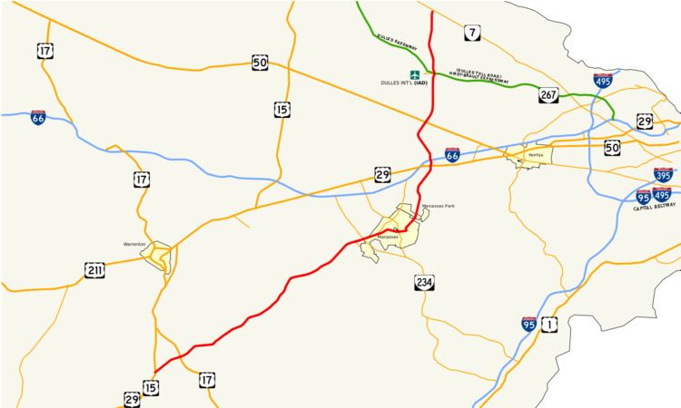
State Route 28 (SR 28) is a primary state highway that traverses the counties of Loudoun, Fairfax, Prince William, and Fauquier in the U.S. state of Virginia. It is a major artery through Northern Virginia.
Contents
- Map of VA 28 Virginia USA
- Fauquier County
- Prince William County
- Fairfax County
- Loudoun County
- Improvement project
- References
Map of VA-28, Virginia, USA
Fauquier County
Route 28 starts as Catlett Road at busy US 29/US 15 in Fauquier County just north of Culpeper County, and intersects US 17 about three miles (5 km) from its beginning. It is two lanes throughout rural Fauquier County with a speed limit of 45 mph (70 km/h) and passes by farms and agricultural areas. Most of the way through Fauquier County Route 28 runs parallel to railroad tracks in order to serve the towns that are placed along them. Several historical markers can be seen along Route 28 as it passes through Fauquier including Supreme Court Justice John Marshall's birthplace and the raid on Catlett Station. For many years the old bridge for Route 28 could be seen just outside Catlett. Historically, the Catlett Fire Department Parade would close Route 28 for several hours each spring, however, this practice was discontinued as traffic became heavier in the 1990s.
Not far from the Prince William county border Route 28 passes the Waat Bodang Temple as Route 28 leaves Fauquier County.
Prince William County
Upon entering Prince William County at Nokesville, SR 28 changes its name to Nokesville Road. North of the town, it expands from two to four lanes just north of SR 215. Further north, it reaches its first grade-separated interchange at SR 234/Prince William Parkway, south of the City of Manassas.
The next interchange is at Wellington Road in Manassas, mostly to grade-separate the crossing of SR 28 with nearby railroad tracks. This interchange was built as an $18.3 million project and certified under the American Recovery and Reinvestment Act of 2009 on October 5, 2009. The contract for construction of this interchange was awarded on July 14, 2010.
SR 28 is a main thoroughfare through Manassas, and separates into a one-way pair of Church and Center Streets in front of a Confederate cemetery. The split routes run through the center of the city and rejoin several blocks later, merging into Centreville Road. The road passes briefly through Manassas Park and then passes through Yorkshire as SR 28 leaves Prince William County where crossing Bull Run into Centreville, Fairfax County.
Fairfax County
Route 28/Centreville Road enters Fairfax County at Centreville, at which point it transitions from an undivided to a divided highway. It starts as a suburban arterial with only at-grade intersections, widening to six lanes at an intersection with Machen Road on the south side of Centreville. In the middle of Centreville, Route 28 intersects Interstate 66 and US 29 at partial cloverleafs; the US 29 interchange has traffic signals on US 29 but none on Route 28, while the interchange with I-66 has traffic signals on mainline Route 28. North of US 29 an expressway with both interchanges and at-grade intersections and changes designation to Sully Road. After a cloverleaf interchange with Westfields Boulevard, Route 28 enters Chantilly, and transitions from an expressway to a six lane freeway.
Route 28 travels through a single-point urban interchange with Willard Road and continues through Chantilly. Route 28 then enters Oak Hill and heads north along the eastern edge of the Washington Dulles International Airport. The next interchanges are for US 50 in Chantilly, the Steven F. Udvar-Hazy Center (an annex of the National Air and Space Museum), McLearen Road, and Frying Pan Road on the south end of Herndon. The road then exits into Loudoun County.
Loudoun County
The first interchange in Loudoun County is at the entrance to Dulles Airport, with access to the airport itself, to the Dulles Toll/Access Road (State Route 267) and Dulles Greenway, and to Innovation Avenue (State Route 209). Continuing north through Loudoun County, Route 28 has interchanges with Old Ox Road and Sterling Boulevard, the former also servicing Herndon. The next interchange is an elaborate interchange with Route 625, Waxpool Road and Church Road, which lead into Ashburn and Sterling, respectively. This interchange features two exits for Waxpool Road from the northbound lanes of Route 28: a left flyover and right loop ramp.
Heading north, Route 28 passes through the industrial and commercial areas of Dulles. It is still known as Sully Road through this stretch, although within Loudoun County it is co-designated as Darrell Green Boulevard, after the former Washington Redskins Hall of Famer (the team's official headquarters is in Ashburn), whose uniform number was 28. A northbound-only, exit-only ramp at Warp Drive is followed by a partial cloverleaf serving Gloucester Parkway and Nokes Boulevard. This interchange leads to both Ashburn and the Dulles Town Center shopping mall. Route 28 ends at VA 7 in Sterling in a complete directional T interchange.
Improvement project
In 1987, Virginia authorized the creation of special tax districts. Fairfax and Loudoun Counties quickly formed the first transportation improvement district in the Commonwealth, by imposing a 20 cent per $100 real estate surcharge on commercial and industrial property located near Route 28. The surcharge financed bonds to pay for improvements to Route 28. From 1988 to 1991, 14 miles (23 km) of Route 28 were widened from two lanes to six lanes and interchanges were built at Routes 50, 7 and the Dulles Toll Road.
The completion schedule for each funded interchange and roadway is as follows:
Clark is currently studying the widening of Route 28 to eight lanes and will file a proposal in the fall of 2010 expected to cover at least 30% of the 6-lane stretch. For a decade there have also been proposals to extend Route 28 to north to connect it with Interstate 370 in Gaithersburg, Maryland over a Techway Bridge across the Potomac River.