
Existed: 1940s – present Length 3.09 km | ||
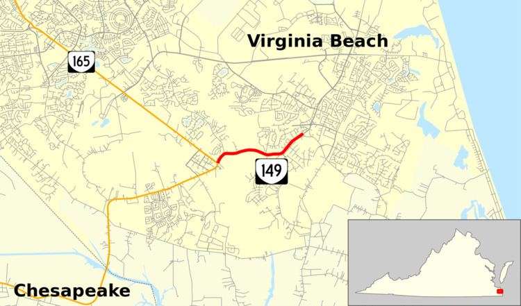 | ||
West end: SR 165 in Virginia Beach East end Princess Anne Road in Virginia Beach | ||
Virginia state route 149 and the road to knotts island nc
State Route 149 (SR 149) is a primary state highway in the U.S. state of Virginia. Known as Princess Anne Road, the state highway runs 1.92 miles (3.09 km) from SR 165 east to a point near the intersection of Princess Anne Road and General Booth Boulevard within the independent city of Virginia Beach.
Contents
- Virginia state route 149 and the road to knotts island nc
- Map of VA 149 Virginia Beach VA USA
- Route description
- Major intersections
- References
Map of VA-149, Virginia Beach, VA, USA
Route description
SR 149 begins in the Princess Anne section of Virginia Beach, which contains the city offices and courthouse, a vestige of when the community was the county seat of Princess Anne County. SR 165 heads northwest as Princess Anne Road toward Norfolk and southwest as North Landing Road toward Chesapeake. SR 149 heads east as a two-lane road that passes by a residential subdivision and through a swampy area where the highway crosses West Neck Creek. The state highway enters a suburban residential area shortly before reaching its terminus at an indeterminate point just west of where Princess Anne Road expands to a four-lane divided highway. Princess Anne Road turns south toward Knotts Island, North Carolina at the following intersection with General Booth Boulevard in the community of Nimmo. General Booth Boulevard heads northeast toward the Virginia Beach Oceanfront.
Major intersections
The entire route is in Virginia Beach.