Virginia Capital Trail is a bicycle and pedestrian trail between Williamsburg, Jamestown and Richmond in the Commonwealth of Virginia in the United States. It is 55 miles (89 km) in length and largely parallels a highway, Virginia Route 5, a Virginia Scenic Byway.
Part of the East Coast Greenway runs along the trail.
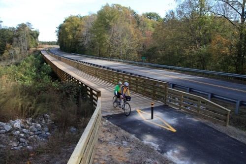
The trail ranges in width between eight and ten feet (2.4 to 3.0 m), and will be paved throughout its entire length to accommodate all modes of non-motorized land transportation. Trail users will share the new $33.6 million Judith Stewart Dresser Bridge over the Chickahominy River with Route 5 motorists, but will use a specially designed area physically separated from motor vehicles. Portions of the Virginia Capital Trail opened beginning in 2006 and the full trail is scheduled for completion by 2015.
Amenities along the Trail include bike rentals, fix-it stations, snack areas, restrooms, geocaching, rain shelters, and a playground at Chickahominy Riverfront Park.
The name derives from the fact that the trail links the three capitals of the British Colony of Virginia and the Commonwealth of Virginia after independence, for a total of over 400 years.As the Trail moves westward, it passes through the former homes of presidents John Tyler, William Henry Harrison, and Benjamin Harrison as well as the habitats of unique wildlife, including one of the largest concentrations of bald eagles in the United States.
Unlike many rail trail projects which utilize former railroad rights-of-way, no railroad was ever built along this corridor. Instead, the Virginia Capital Trail essentially parallels the north shore of the James River and Virginia Route 5 approximately 55 miles (89 km) between the two cities, from the Capitol in Colonial Williamsburg through portions of James City County, Charles City County, and Henrico County to the current Virginia State Capitol in Richmond.
Virginia Capital Trail Foundation (VCTF) is a public-private partnership whose mission is to enhance, promote, manage, and advocate for the continued development of the Virginia Capital Trail. The Virginia Department of Transportation (VDOT), a state agency, describes their relationship as "working partners on this unique project."
Sections and schedule for completion
As of October 2015, the Virginia Capital Trail is complete.
Colonial Parkway Phase (open in Williamsburg and along Colonial Parkway)
Greensprings Phase (2.4 miles) - opened in 2006
Chickahominy Phase (4.8 miles) - opened in 2007
Sherwood Forest Phase (13 miles) – completion in late 2014
Charles City Courthouse Phase (7.3 miles) – opened in 2009
New Market Heights Phase (10.3 miles) – completion in fall 2015
Varina/Park Phase (11.3 miles) – completion in summer 2015
Richmond Riverfront Phase, Section Two (1.5 miles) – completion in summer 2015
Richmond Riverfront Phase, Section One (.8 miles) – opened in 2010
(listed east to west)
City of Williamsburg (Capital from 1699-1780)
Colonial Williamsburg
Old Capitol Building
Duke of Gloucester Street
Bruton Parish Church
Governor's Palace
Merchants Square
The College of William & Mary
Colonial Parkway
James City County (one of the original shires of Virginia)
Jamestown, Virginia (Capital from 1607-1699)
Historic Jamestowne (sic)
Jamestown Settlement
Chickahominy Wildlife Refuge
Jamestown Ferry
Charles City County (another of the original shires of Virginia)
Sherwood Forest Plantation is the home of United States President John Tyler, the first Vice President to ascend to the Presidency. Tyler was twice Governor of Virginia, a U.S. Senator, a member of the U.S. House of Representatives, a Virginia state senator and member of the Virginia House of Delegates. A graduate of The College of William & Mary, he later became Chancellor of that institution. As a supporter of state's rights, he re-entered public service in 1861 as an elected member of the Confederate Congress. He died in 1862. The house and its 1,600 acres (6.5 km2) have been continuously owned by his direct descendants. In the mid-1970s, the residence was restored by President Tyler's grandson and his wife, the current owners. The House, circa 1730, is "Virginia Tidewater" in architectural design, and is the longest frame dwelling in America. It was expanded to its present length, 300 feet (90 m), by President Tyler in 1845, when he added the 68 foot (21 m) ballroom designed for dancing the Virginia reel. Sherwood Forest is a National Historic Landmark, Virginia Historic Landmark, and listed on the National Register of Historic Places.
Fort Pocahontas notable for construction by African American soldiers of the United States Colored Troops under the command of Union Brigadier General Edward Augustus Wild during the American Civil War.
Evelynton Plantation was originally part of William Byrd's expansive Westover Plantation. Named for Byrd's daughter, Evelyn, this site has been home to the Ruffin family since 1847. The 2,500 acres (10 km2) farm is still family owned and operated. It is listed on the National Register of Historic Places.
North Bend Plantation was built in 1819 by John Minge. In 1853 the home was doubled in size by Thomas Willcox. Architectural detailing from the expansion included Greek Revival detailing reminiscent of the designs of builder/architect Asher Benjamin. During the American Civil War, in 1864, it served as the headquarters of Union General Philip Sheridan. The home has been in Copland family since 1916. It is listed on the National Register of Historic Places.
Piney Grove at Southall's Plantation was established in the eighteenth century as a seat of the Southall family. During the late eighteenth century the 300-acre (1.2 km2) plantation was owned by Furneau Southall. The original log portion of Piney Grove was built before 1790 as a corn crib, later converted and enlarged into a general merchandise, and in 1905 enlarged and transformed into a residence. The home survives as a rare and well-preserved example of Early Virginia Log Architecture. It is listed on the National Register of Historic Places.
Edgewood Plantation and Harrison's Mill is a unique surviving example of Gothic Revival architecture along State Route 5 and the James River. Edgewood was once part of Berkeley Plantation and the mill was constructed by Benjamin Harrison V. It is listed on the National Register of Historic Places.
Westover Plantation was built circa 1730 by William Byrd II, the founder of Richmond. It is noteworthy for its secret passages, magnificent gardens, and architectural details. The grounds and garden are open daily, but the house is not open to the public.
Berkeley Plantation was long the seat of the Harrison family, one of the First Families of Virginia. It was the birthplace of Benjamin Harrison V, son of the builder, who was a signer of the Declaration of Independence and three-time Governor of Virginia. His third son, William Henry Harrison, was born at Berkeley. A famous Indian fighter known as "Tippecanoe", William Henry Harrison later became the ninth President of the United States, in 1841, although he died shortly after taking office. His grandson, Benjamin Harrison, was the 23rd President. On December 4, 1619, early settlers from England came ashore at Berkeley and observed the first official Thanksgiving in America. It was also the site of the first playing of Taps at the conclusion of the Peninsula Campaign of 1862 during the American Civil War.
Charles City Courthouse
Benjamin Harrison Memorial Bridge
Shirley Plantation, settled in 1613, is the oldest plantation in Virginia and the oldest family-owned business in North America, dating back to 1638. Occupied by the Hill family and their descendants since 1738, the mother of Confederate General Robert E. Lee, Anne Hill Carter Lee, was born at Shirley and in 1793, married "Light Horse Harry" Lee in the mansion's parlor. Shirley Plantation has been designated a National Historic Landmark.
Belle Air Plantation is a unique surviving example of a wooden house with postmedieval-type exposed interior framing, and is probably the oldest plantation dwelling along State Route 5. The original five-bay portion of Belle Air possesses architectural details characteristic of seventeenth century construction with a floor plan and façade fenestration characteristic of 18th-century design. It is listed on the National Register of Historic Places.
Henrico County, (another of the original shires of Virginia)
Curles Neck Plantation, home of Nathaniel Bacon, the leader of 1676's Bacon's Rebellion, still a working farm and not open to public
Varina Farms, home of John Rolfe and Pocahontas between 1614 and 1616, also still a working farm and not open to public
Richmond National Battlefield Park (units including Fort Harrison)
City of Richmond (capital 1780-present)
Tobacco Row a U.S. historic district fronting the James River directly east of Shockoe Slip and Shockoe Bottom with a bunch of old factories and warehouses now converted into apartments and offices
Church Hill a U.S. historic district located on ground elevation higher than that of Downtown and the area to the west of it, location of St. John's Church
St. John's Church site of Patrick Henry's famous "Give me Liberty, or give me Death!" speech
Shockoe Bottom a U.S. historic district in Downtown Richmond that was a bunch of old factories and warehouses and has since converted into mixed use residential buildings, restaurants and bars
Shockoe Slip a U.S. historic district in Downtown Richmond area with a bunch of historic structures mostly used as office buildings, shops and restaurants
Main Street Station historic station renovated and restored in 2003 with use as a multi-modal Amtrak train station and GRTC bus depot
Canal Walk completed in 1999, historic walk through restored canal, access to James River and Historic Tredegar Iron Works
American Civil War Center at Historic Tredegar Iron Works old iron works and artillery for use in the American Civil War
Virginia State Capitol