
Country Ukraine Raion Poliske Elevation 151 m (495 ft) Population 3 (2012) | Oblast Kiev Founded 1926 Area code(s) +380 4592 Postal code 07011 | |
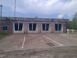 | ||
Vilcha (Ukrainian: Вільча, Russian: Вильча) is a Ukrainian abandoned settlement and former town in the Chernobyl Exclusion Zone, part of Poliske Raion, Kiev Oblast.
Contents
History
The town was founded in 1926 on the site of a settlement named Oleksiivka (Ukrainian: Олексіївка). After the 1986 accident at the Chernobyl Nuclear Power Plant, 45 km far from Vilcha, the town was not included into the "Exclusion Zone" before 1993. During 1993 to 1996, most of the 2,000 residents moved to Kharkiv Oblast, where they founded a New Vilcha (709 km away), few kilometres south of the town of Vovchansk.
The ghost town, today one of the checkpoints to the Exclusion Zone, was resettled by few samosely some years later.
Geography
Located near the borders with Zhytomyr Oblast and the Belarusian Oblast of Gomel, Vilcha is located in the middle of the natural region of Polesia, close to its radioecological reserve. It is 17 km from Poliske, 40 km from Krasiatychi (the raion's administrative seat), 43 km from Pripyat, 44 km from Ovruch and 95 km from Slavutych.
Transport
The town is crossed in the middle by the regional highway P02 Ovruch-Kiev (150 km south), and is the southern end of the T1035 road from Oleksandrivka, in Belarus, that continues as P37 highway to Naroulia and Mazyr (95 km north). It also has a railway station, officially in service but without passenger traffic, on the Chernihiv–Ovruch line.